You are here: Home > Network List > NR - NARS Array Stations List
> Station NE207 Qangwa > Earthquake Result Viewer
NE207 Qangwa - Earthquake Result Viewer
| Earthquake location: |
Java Sea |
| Earthquake latitude/longitude: |
-4.9/108.2 |
| Earthquake time(UTC): |
2016/10/19 (293) 00:26:01 GMT |
| Earthquake Depth: |
614 km |
| Earthquake Magnitude: |
6.6 MWW, 6.6 MWC, 6.7 MWB |
| Earthquake Catalog/Contributor: |
NEIC PDE/NEIC COMCAT |
|
| Network: |
NR NARS Array |
| Station: |
NE207 Qangwa |
| Lat/Lon: |
19.53 S/21.17 E |
| Elevation: |
1094 m |
|
| Distance: |
85.6 deg |
| Az: |
250.857 deg |
| Baz: |
93.567 deg |
| Ray Param: |
0.04287403 |
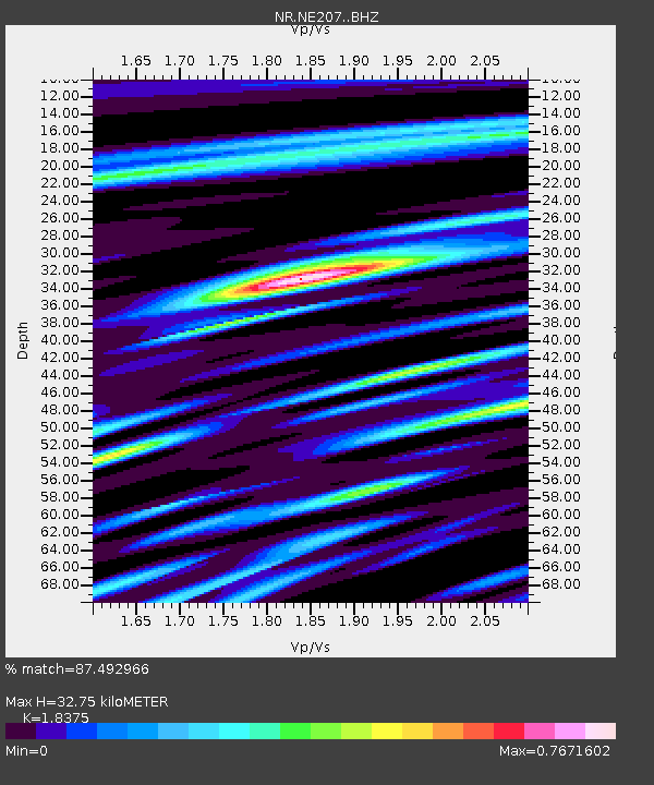
| Estimated Moho Depth: |
32.75 km |
| Estimated Crust Vp/Vs: |
1.84 |
| Assumed Crust Vp: |
6.577 km/s |
| Estimated Crust Vs: |
3.579 km/s |
| Estimated Crust Poisson's Ratio: |
0.29 |
|
| Radial Match: |
87.492966 % |
| Radial Bump: |
400 |
| Transverse Match: |
78.46205 % |
| Transverse Bump: |
400 |
| SOD ConfigId: |
11737051 |
| Insert Time: |
2019-04-25 20:10:33.998 +0000 |
| GWidth: |
2.5 |
| Max Bumps: |
400 |
| Tol: |
0.001 |
|

Signal To Noise
| Channel | StoN | STA | LTA |
| NR:NE207: :BHZ:20161019T00:37:04.558994Z | 19.761051 | 2.4103774E-6 | 1.2197617E-7 |
| NR:NE207: :BHN:20161019T00:37:04.558994Z | 1.3803767 | 1.9822424E-7 | 1.4360155E-7 |
| NR:NE207: :BHE:20161019T00:37:04.558994Z | 6.3431387 | 8.5598725E-7 | 1.3494694E-7 |
| Arrivals |
| Ps | 4.3 SECOND |
| PpPs | 14 SECOND |
| PsPs/PpSs | 18 SECOND |


