You are here: Home > Network List > NR - NARS Array Stations List
> Station NE211 Kacgae > Earthquake Result Viewer
NE211 Kacgae - Earthquake Result Viewer
| Earthquake location: |
Java Sea |
| Earthquake latitude/longitude: |
-4.9/108.2 |
| Earthquake time(UTC): |
2016/10/19 (293) 00:26:01 GMT |
| Earthquake Depth: |
614 km |
| Earthquake Magnitude: |
6.6 MWW, 6.6 MWC, 6.7 MWB |
| Earthquake Catalog/Contributor: |
NEIC PDE/NEIC COMCAT |
|
| Network: |
NR NARS Array |
| Station: |
NE211 Kacgae |
| Lat/Lon: |
22.85 S/22.21 E |
| Elevation: |
1153 m |
|
| Distance: |
84.4 deg |
| Az: |
247.596 deg |
| Baz: |
92.91 deg |
| Ray Param: |
0.043672275 |
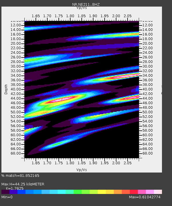
| Estimated Moho Depth: |
44.25 km |
| Estimated Crust Vp/Vs: |
1.76 |
| Assumed Crust Vp: |
6.576 km/s |
| Estimated Crust Vs: |
3.731 km/s |
| Estimated Crust Poisson's Ratio: |
0.26 |
|
| Radial Match: |
81.852165 % |
| Radial Bump: |
400 |
| Transverse Match: |
72.98961 % |
| Transverse Bump: |
400 |
| SOD ConfigId: |
11737051 |
| Insert Time: |
2019-04-25 20:10:36.380 +0000 |
| GWidth: |
2.5 |
| Max Bumps: |
400 |
| Tol: |
0.001 |
|

Signal To Noise
| Channel | StoN | STA | LTA |
| NR:NE211: :BHZ:20161019T00:36:59.001987Z | 24.883638 | 4.2595207E-6 | 1.7117758E-7 |
| NR:NE211: :BHN:20161019T00:36:59.001987Z | 1.5641888 | 3.558843E-7 | 2.2752003E-7 |
| NR:NE211: :BHE:20161019T00:36:59.001987Z | 5.1475687 | 1.3241172E-6 | 2.5723156E-7 |
| Arrivals |
| Ps | 5.3 SECOND |
| PpPs | 18 SECOND |
| PsPs/PpSs | 23 SECOND |


