You are here: Home > Network List > TA - USArray Transportable Network (new EarthScope stations) Stations List
> Station I23K Minto, Yukon-Koyukuk, AK, USA > Earthquake Result Viewer
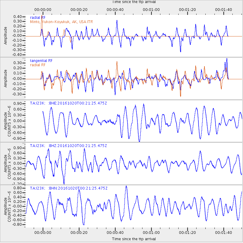
I23K Minto, Yukon-Koyukuk, AK, USA - Earthquake Result Viewer
*The percent match for this event was below the threshold and hence no stack was calculated.
| Earthquake location: |
Northern Mid-Atlantic Ridge |
| Earthquake latitude/longitude: |
13.3/-44.9 |
| Earthquake time(UTC): |
2016/10/20 (294) 00:09:26 GMT |
| Earthquake Depth: |
10 km |
| Earthquake Magnitude: |
5.7 MWP |
| Earthquake Catalog/Contributor: |
NEIC PDE/NEIC COMCAT |
|
| Network: |
TA USArray Transportable Network (new EarthScope stations) |
| Station: |
I23K Minto, Yukon-Koyukuk, AK, USA |
| Lat/Lon: |
65.15 N/149.36 W |
| Elevation: |
149 m |
|
| Distance: |
84.0 deg |
| Az: |
335.709 deg |
| Baz: |
71.378 deg |
| Ray Param: |
$rayparam |
*The percent match for this event was below the threshold and hence was not used in the summary stack. |
|
| Radial Match: |
62.288715 % |
| Radial Bump: |
342 |
| Transverse Match: |
51.888638 % |
| Transverse Bump: |
400 |
| SOD ConfigId: |
11737051 |
| Insert Time: |
2019-04-25 20:29:06.203 +0000 |
| GWidth: |
2.5 |
| Max Bumps: |
400 |
| Tol: |
0.001 |
|
Signal To Noise
| Channel | StoN | STA | LTA |
| TA:I23K: :BHZ:20161020T00:21:25.475Z | 2.2660334 | 5.1739073E-7 | 2.283244E-7 |
| TA:I23K: :BHN:20161020T00:21:25.475Z | 1.3125275 | 3.837467E-7 | 2.923723E-7 |
| TA:I23K: :BHE:20161020T00:21:25.475Z | 0.337113 | 1.2683391E-7 | 3.762356E-7 |
| Arrivals |
| Ps | |
| PpPs | |
| PsPs/PpSs | |


