You are here: Home > Network List > TA - USArray Transportable Network (new EarthScope stations) Stations List
> Station R11A Troy Canyon, Currant, NV, USA > Earthquake Result Viewer
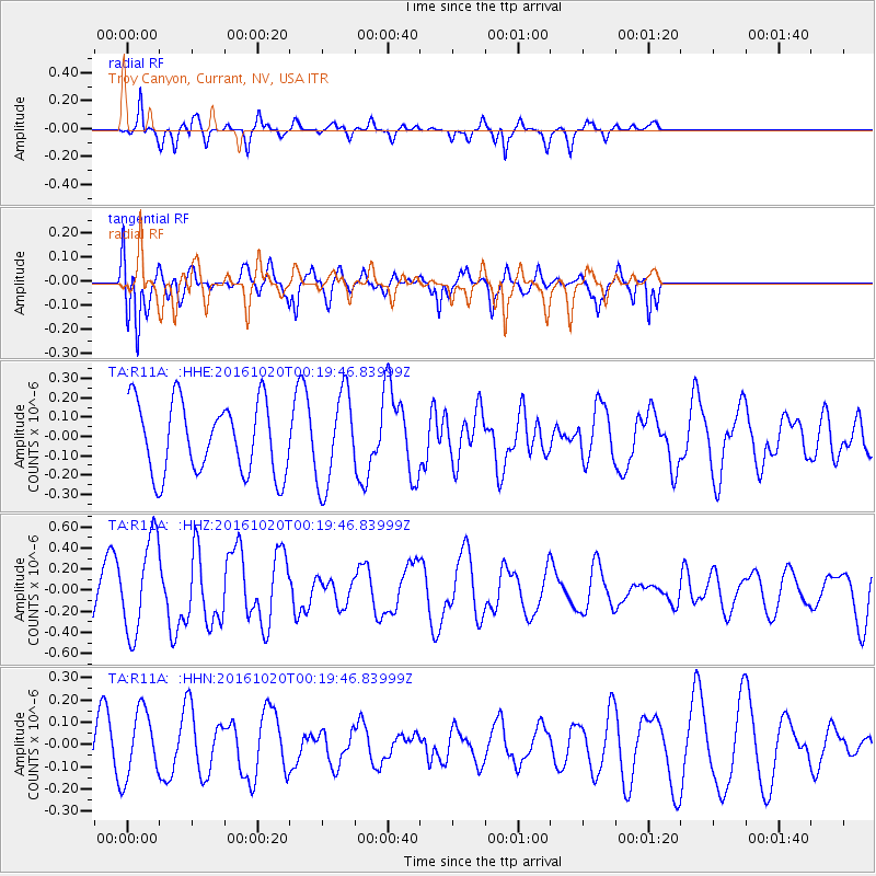
R11A Troy Canyon, Currant, NV, USA - Earthquake Result Viewer
*The percent match for this event was below the threshold and hence no stack was calculated.
| Earthquake location: |
Northern Mid-Atlantic Ridge |
| Earthquake latitude/longitude: |
13.3/-44.9 |
| Earthquake time(UTC): |
2016/10/20 (294) 00:09:26 GMT |
| Earthquake Depth: |
10 km |
| Earthquake Magnitude: |
5.7 MWP |
| Earthquake Catalog/Contributor: |
NEIC PDE/NEIC COMCAT |
|
| Network: |
TA USArray Transportable Network (new EarthScope stations) |
| Station: |
R11A Troy Canyon, Currant, NV, USA |
| Lat/Lon: |
38.35 N/115.59 W |
| Elevation: |
1756 m |
|
| Distance: |
66.8 deg |
| Az: |
306.149 deg |
| Baz: |
91.171 deg |
| Ray Param: |
$rayparam |
*The percent match for this event was below the threshold and hence was not used in the summary stack. |
|
| Radial Match: |
69.04661 % |
| Radial Bump: |
276 |
| Transverse Match: |
76.245674 % |
| Transverse Bump: |
371 |
| SOD ConfigId: |
11737051 |
| Insert Time: |
2019-04-25 20:29:45.229 +0000 |
| GWidth: |
2.5 |
| Max Bumps: |
400 |
| Tol: |
0.001 |
|
Signal To Noise
| Channel | StoN | STA | LTA |
| TA:R11A: :HHZ:20161020T00:19:46.83999Z | 1.7444819 | 4.5039513E-7 | 2.5818275E-7 |
| TA:R11A: :HHN:20161020T00:19:46.83999Z | 1.1293077 | 1.500816E-7 | 1.3289699E-7 |
| TA:R11A: :HHE:20161020T00:19:46.83999Z | 1.2934378 | 2.3590387E-7 | 1.8238515E-7 |
| Arrivals |
| Ps | |
| PpPs | |
| PsPs/PpSs | |


