You are here: Home > Network List > CI - Caltech Regional Seismic Network Stations List
> Station MPM Manuel Prospect Mine, California, USA > Earthquake Result Viewer
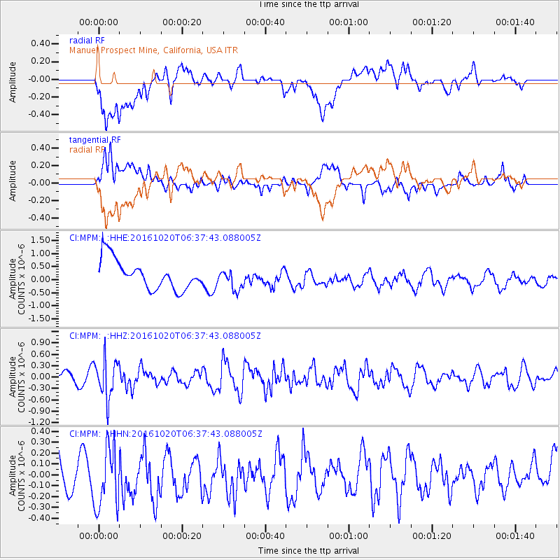
MPM Manuel Prospect Mine, California, USA - Earthquake Result Viewer
*The percent match for this event was below the threshold and hence no stack was calculated.
| Earthquake location: |
Volcano Islands, Japan Region |
| Earthquake latitude/longitude: |
22.3/143.8 |
| Earthquake time(UTC): |
2016/10/20 (294) 06:25:56 GMT |
| Earthquake Depth: |
108 km |
| Earthquake Magnitude: |
5.7 MB |
| Earthquake Catalog/Contributor: |
NEIC PDE/NEIC COMCAT |
|
| Network: |
CI Caltech Regional Seismic Network |
| Station: |
MPM Manuel Prospect Mine, California, USA |
| Lat/Lon: |
36.06 N/117.49 W |
| Elevation: |
185 m |
|
| Distance: |
83.9 deg |
| Az: |
53.654 deg |
| Baz: |
292.967 deg |
| Ray Param: |
$rayparam |
*The percent match for this event was below the threshold and hence was not used in the summary stack. |
|
| Radial Match: |
26.407494 % |
| Radial Bump: |
400 |
| Transverse Match: |
43.089996 % |
| Transverse Bump: |
400 |
| SOD ConfigId: |
11737051 |
| Insert Time: |
2019-04-25 20:40:12.874 +0000 |
| GWidth: |
2.5 |
| Max Bumps: |
400 |
| Tol: |
0.001 |
|
Signal To Noise
| Channel | StoN | STA | LTA |
| CI:MPM: :HHZ:20161020T06:37:43.088005Z | 2.4629872 | 5.1575034E-7 | 2.0940033E-7 |
| CI:MPM: :HHN:20161020T06:37:43.088005Z | 1.162182 | 3.1198041E-7 | 2.684437E-7 |
| CI:MPM: :HHE:20161020T06:37:43.088005Z | 0.74659127 | 4.186111E-7 | 5.606965E-7 |
| Arrivals |
| Ps | |
| PpPs | |
| PsPs/PpSs | |


