You are here: Home > Network List > CI - Caltech Regional Seismic Network Stations List
> Station SMM Simmler, CA, USA > Earthquake Result Viewer
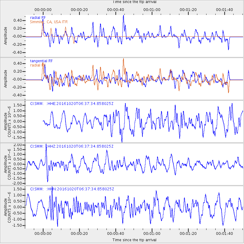
SMM Simmler, CA, USA - Earthquake Result Viewer
*The percent match for this event was below the threshold and hence no stack was calculated.
| Earthquake location: |
Volcano Islands, Japan Region |
| Earthquake latitude/longitude: |
22.3/143.8 |
| Earthquake time(UTC): |
2016/10/20 (294) 06:25:56 GMT |
| Earthquake Depth: |
108 km |
| Earthquake Magnitude: |
5.7 MB |
| Earthquake Catalog/Contributor: |
NEIC PDE/NEIC COMCAT |
|
| Network: |
CI Caltech Regional Seismic Network |
| Station: |
SMM Simmler, CA, USA |
| Lat/Lon: |
35.31 N/120.00 W |
| Elevation: |
599 m |
|
| Distance: |
82.3 deg |
| Az: |
55.126 deg |
| Baz: |
291.689 deg |
| Ray Param: |
$rayparam |
*The percent match for this event was below the threshold and hence was not used in the summary stack. |
|
| Radial Match: |
58.490063 % |
| Radial Bump: |
400 |
| Transverse Match: |
54.18348 % |
| Transverse Bump: |
400 |
| SOD ConfigId: |
11737051 |
| Insert Time: |
2019-04-25 20:40:32.883 +0000 |
| GWidth: |
2.5 |
| Max Bumps: |
400 |
| Tol: |
0.001 |
|
Signal To Noise
| Channel | StoN | STA | LTA |
| CI:SMM: :HHZ:20161020T06:37:34.858025Z | 3.1404095 | 8.1488304E-7 | 2.5948304E-7 |
| CI:SMM: :HHN:20161020T06:37:34.858025Z | 1.1861668 | 5.587395E-7 | 4.7104635E-7 |
| CI:SMM: :HHE:20161020T06:37:34.858025Z | 0.8790795 | 4.3752405E-7 | 4.9770705E-7 |
| Arrivals |
| Ps | |
| PpPs | |
| PsPs/PpSs | |


