You are here: Home > Network List > G - GEOSCOPE Stations List
> Station MPG Montagne des Peres, French Guyana > Earthquake Result Viewer
MPG Montagne des Peres, French Guyana - Earthquake Result Viewer
| Earthquake location: |
Near Coast Of Central Chile |
| Earthquake latitude/longitude: |
-30.3/-71.7 |
| Earthquake time(UTC): |
2015/10/05 (278) 16:33:26 GMT |
| Earthquake Depth: |
35 km |
| Earthquake Magnitude: |
6.0 MB |
| Earthquake Catalog/Contributor: |
NEIC PDE/NEIC ALERT |
|
| Network: |
G GEOSCOPE |
| Station: |
MPG Montagne des Peres, French Guyana |
| Lat/Lon: |
5.11 N/52.64 W |
| Elevation: |
147 m |
|
| Distance: |
39.6 deg |
| Az: |
30.6 deg |
| Baz: |
206.232 deg |
| Ray Param: |
0.074796215 |
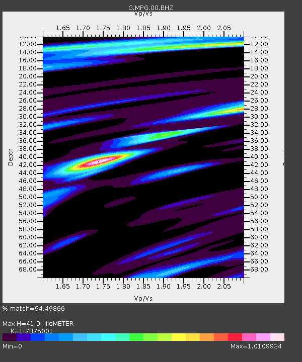
| Estimated Moho Depth: |
41.0 km |
| Estimated Crust Vp/Vs: |
1.74 |
| Assumed Crust Vp: |
6.472 km/s |
| Estimated Crust Vs: |
3.725 km/s |
| Estimated Crust Poisson's Ratio: |
0.25 |
|
| Radial Match: |
94.49866 % |
| Radial Bump: |
329 |
| Transverse Match: |
67.782585 % |
| Transverse Bump: |
400 |
| SOD ConfigId: |
1156111 |
| Insert Time: |
2015-10-19 17:11:18.960 +0000 |
| GWidth: |
2.5 |
| Max Bumps: |
400 |
| Tol: |
0.001 |
|
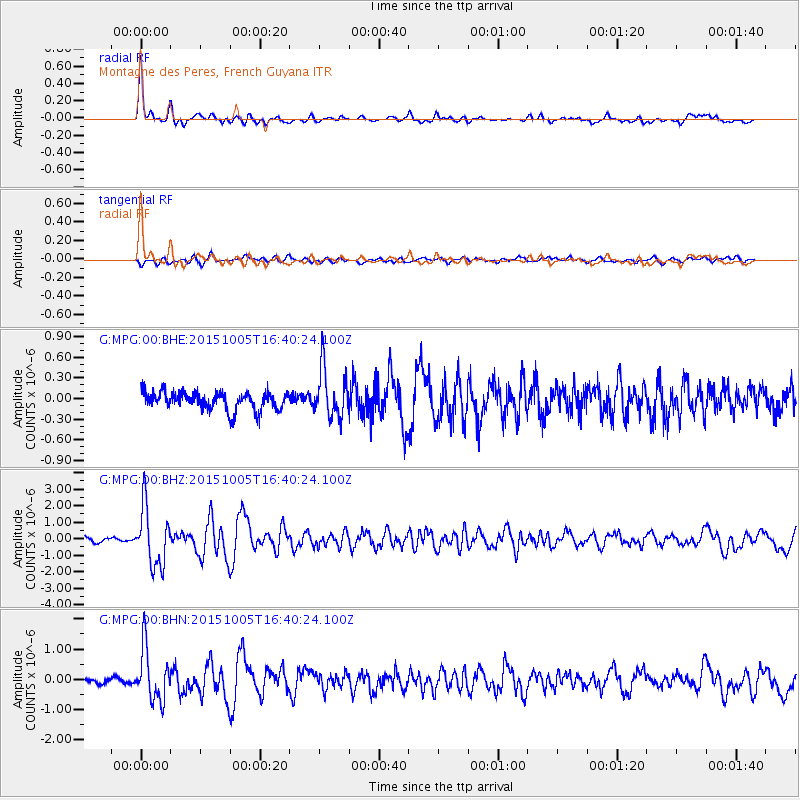
Signal To Noise
| Channel | StoN | STA | LTA |
| G:MPG:00:BHZ:20151005T16:40:24.100Z | 13.670139 | 1.7693255E-6 | 1.2942995E-7 |
| G:MPG:00:BHN:20151005T16:40:24.100Z | 10.327077 | 8.656777E-7 | 8.382601E-8 |
| G:MPG:00:BHE:20151005T16:40:24.100Z | 2.7428749 | 3.5740683E-7 | 1.3030373E-7 |
| Arrivals |
| Ps | 5.0 SECOND |
| PpPs | 16 SECOND |
| PsPs/PpSs | 21 SECOND |


