You are here: Home > Network List > TA - USArray Transportable Network (new EarthScope stations) Stations List
> Station J26L Joseph Creek, AK, USA > Earthquake Result Viewer
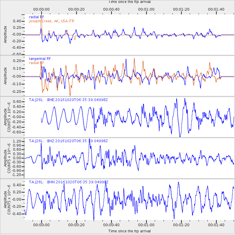
J26L Joseph Creek, AK, USA - Earthquake Result Viewer
*The percent match for this event was below the threshold and hence no stack was calculated.
| Earthquake location: |
Volcano Islands, Japan Region |
| Earthquake latitude/longitude: |
22.3/143.8 |
| Earthquake time(UTC): |
2016/10/20 (294) 06:25:56 GMT |
| Earthquake Depth: |
108 km |
| Earthquake Magnitude: |
5.7 MB |
| Earthquake Catalog/Contributor: |
NEIC PDE/NEIC COMCAT |
|
| Network: |
TA USArray Transportable Network (new EarthScope stations) |
| Station: |
J26L Joseph Creek, AK, USA |
| Lat/Lon: |
64.50 N/143.56 W |
| Elevation: |
1144 m |
|
| Distance: |
62.7 deg |
| Az: |
27.719 deg |
| Baz: |
264.479 deg |
| Ray Param: |
$rayparam |
*The percent match for this event was below the threshold and hence was not used in the summary stack. |
|
| Radial Match: |
61.478733 % |
| Radial Bump: |
400 |
| Transverse Match: |
51.404476 % |
| Transverse Bump: |
400 |
| SOD ConfigId: |
11737051 |
| Insert Time: |
2019-04-25 20:50:09.252 +0000 |
| GWidth: |
2.5 |
| Max Bumps: |
400 |
| Tol: |
0.001 |
|
Signal To Noise
| Channel | StoN | STA | LTA |
| TA:J26L: :BHZ:20161020T06:35:39.04998Z | 5.35808 | 4.2335282E-7 | 7.901204E-8 |
| TA:J26L: :BHN:20161020T06:35:39.04998Z | 0.5452799 | 1.5754588E-7 | 2.8892663E-7 |
| TA:J26L: :BHE:20161020T06:35:39.04998Z | 1.0552273 | 2.5629188E-7 | 2.428784E-7 |
| Arrivals |
| Ps | |
| PpPs | |
| PsPs/PpSs | |


