You are here: Home > Network List > TA - USArray Transportable Network (new EarthScope stations) Stations List
> Station T25A Trinidad, CO, USA > Earthquake Result Viewer
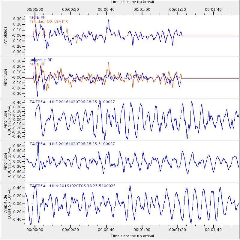
T25A Trinidad, CO, USA - Earthquake Result Viewer
*The percent match for this event was below the threshold and hence no stack was calculated.
| Earthquake location: |
Volcano Islands, Japan Region |
| Earthquake latitude/longitude: |
22.3/143.8 |
| Earthquake time(UTC): |
2016/10/20 (294) 06:25:56 GMT |
| Earthquake Depth: |
108 km |
| Earthquake Magnitude: |
5.7 MB |
| Earthquake Catalog/Contributor: |
NEIC PDE/NEIC COMCAT |
|
| Network: |
TA USArray Transportable Network (new EarthScope stations) |
| Station: |
T25A Trinidad, CO, USA |
| Lat/Lon: |
37.14 N/104.41 W |
| Elevation: |
2017 m |
|
| Distance: |
92.8 deg |
| Az: |
47.961 deg |
| Baz: |
300.587 deg |
| Ray Param: |
$rayparam |
*The percent match for this event was below the threshold and hence was not used in the summary stack. |
|
| Radial Match: |
52.831985 % |
| Radial Bump: |
400 |
| Transverse Match: |
75.16624 % |
| Transverse Bump: |
400 |
| SOD ConfigId: |
11737051 |
| Insert Time: |
2019-04-25 20:50:57.857 +0000 |
| GWidth: |
2.5 |
| Max Bumps: |
400 |
| Tol: |
0.001 |
|
Signal To Noise
| Channel | StoN | STA | LTA |
| TA:T25A: :HHZ:20161020T06:38:25.510002Z | 1.9879487 | 4.0965693E-7 | 2.0607018E-7 |
| TA:T25A: :HHN:20161020T06:38:25.510002Z | 1.2121772 | 2.8228425E-7 | 2.3287376E-7 |
| TA:T25A: :HHE:20161020T06:38:25.510002Z | 1.22812 | 2.0874282E-7 | 1.699694E-7 |
| Arrivals |
| Ps | |
| PpPs | |
| PsPs/PpSs | |


