You are here: Home > Network List > TJ - Tajikistan National Seismic Network Stations List
> Station GARM Garm, Tajikistan > Earthquake Result Viewer
GARM Garm, Tajikistan - Earthquake Result Viewer
| Earthquake location: |
Volcano Islands, Japan Region |
| Earthquake latitude/longitude: |
22.3/143.8 |
| Earthquake time(UTC): |
2016/10/20 (294) 06:25:56 GMT |
| Earthquake Depth: |
108 km |
| Earthquake Magnitude: |
5.7 MB |
| Earthquake Catalog/Contributor: |
NEIC PDE/NEIC COMCAT |
|
| Network: |
TJ Tajikistan National Seismic Network |
| Station: |
GARM Garm, Tajikistan |
| Lat/Lon: |
39.00 N/70.32 E |
| Elevation: |
1305 m |
|
| Distance: |
63.8 deg |
| Az: |
303.633 deg |
| Baz: |
81.784 deg |
| Ray Param: |
0.059057627 |
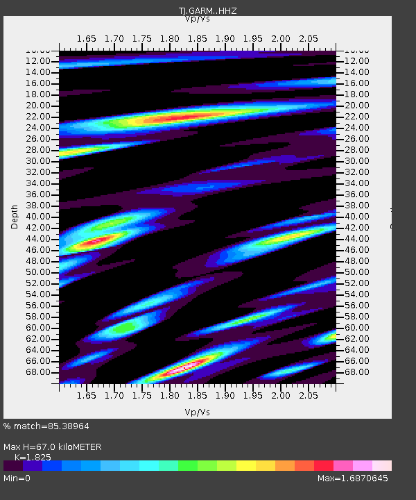
| Estimated Moho Depth: |
67.0 km |
| Estimated Crust Vp/Vs: |
1.83 |
| Assumed Crust Vp: |
6.306 km/s |
| Estimated Crust Vs: |
3.455 km/s |
| Estimated Crust Poisson's Ratio: |
0.29 |
|
| Radial Match: |
85.38964 % |
| Radial Bump: |
400 |
| Transverse Match: |
80.50788 % |
| Transverse Bump: |
400 |
| SOD ConfigId: |
11737051 |
| Insert Time: |
2019-04-25 20:51:13.389 +0000 |
| GWidth: |
2.5 |
| Max Bumps: |
400 |
| Tol: |
0.001 |
|
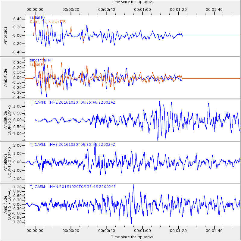
Signal To Noise
| Channel | StoN | STA | LTA |
| TJ:GARM: :HHZ:20161020T06:35:46.220024Z | 2.6107464 | 3.7258542E-7 | 1.4271221E-7 |
| TJ:GARM: :HHN:20161020T06:35:46.220024Z | 1.5436972 | 1.3606483E-7 | 8.8142166E-8 |
| TJ:GARM: :HHE:20161020T06:35:46.220024Z | 2.1310108 | 1.9270992E-7 | 9.043122E-8 |
| Arrivals |
| Ps | 9.1 SECOND |
| PpPs | 29 SECOND |
| PsPs/PpSs | 38 SECOND |


