You are here: Home > Network List > BK - Berkeley Digital Seismograph Network Stations List
> Station CMB Columbia College, California, USA > Earthquake Result Viewer
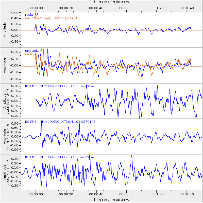
CMB Columbia College, California, USA - Earthquake Result Viewer
*The percent match for this event was below the threshold and hence no stack was calculated.
| Earthquake location: |
Kuril Islands |
| Earthquake latitude/longitude: |
45.4/150.4 |
| Earthquake time(UTC): |
1996/02/14 (045) 20:31:06 GMT |
| Earthquake Depth: |
33 km |
| Earthquake Magnitude: |
5.9 MB, 5.2 MS, 5.8 UNKNOWN, 5.8 MW |
| Earthquake Catalog/Contributor: |
WHDF/NEIC |
|
| Network: |
BK Berkeley Digital Seismograph Network |
| Station: |
CMB Columbia College, California, USA |
| Lat/Lon: |
38.03 N/120.39 W |
| Elevation: |
719 m |
|
| Distance: |
63.7 deg |
| Az: |
61.702 deg |
| Baz: |
308.206 deg |
| Ray Param: |
$rayparam |
*The percent match for this event was below the threshold and hence was not used in the summary stack. |
|
| Radial Match: |
71.30653 % |
| Radial Bump: |
400 |
| Transverse Match: |
61.97275 % |
| Transverse Bump: |
400 |
| SOD ConfigId: |
4480 |
| Insert Time: |
2010-03-05 18:59:26.661 +0000 |
| GWidth: |
2.5 |
| Max Bumps: |
400 |
| Tol: |
0.001 |
|
Signal To Noise
| Channel | StoN | STA | LTA |
| BK:CMB: :BHN:19960214T20:41:03.927014Z | 3.976147 | 3.8324504E-7 | 9.638603E-8 |
| BK:CMB: :BHE:19960214T20:41:03.927014Z | 0.9095229 | 1.1977575E-7 | 1.3169074E-7 |
| BK:CMB: :BHZ:19960214T20:41:03.927014Z | 1.4432137 | 1.1854759E-7 | 8.21414E-8 |
| Arrivals |
| Ps | |
| PpPs | |
| PsPs/PpSs | |


