You are here: Home > Network List > TA - USArray Transportable Network (new EarthScope stations) Stations List
> Station G22K Bettles, AK, USA > Earthquake Result Viewer
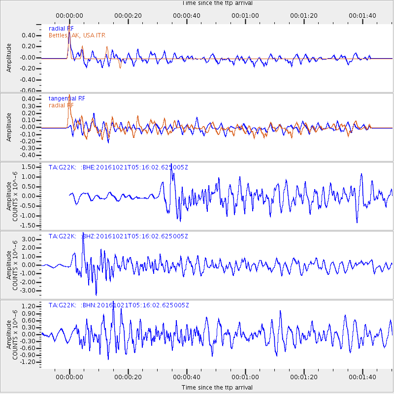
G22K Bettles, AK, USA - Earthquake Result Viewer
*The percent match for this event was below the threshold and hence no stack was calculated.
| Earthquake location: |
Western Honshu, Japan |
| Earthquake latitude/longitude: |
35.4/133.8 |
| Earthquake time(UTC): |
2016/10/21 (295) 05:07:23 GMT |
| Earthquake Depth: |
10 km |
| Earthquake Magnitude: |
6.2 MWW, 6.6 MI |
| Earthquake Catalog/Contributor: |
NEIC PDE/NEIC COMCAT |
|
| Network: |
TA USArray Transportable Network (new EarthScope stations) |
| Station: |
G22K Bettles, AK, USA |
| Lat/Lon: |
66.92 N/151.51 W |
| Elevation: |
205 m |
|
| Distance: |
52.1 deg |
| Az: |
28.815 deg |
| Baz: |
272.091 deg |
| Ray Param: |
$rayparam |
*The percent match for this event was below the threshold and hence was not used in the summary stack. |
|
| Radial Match: |
69.07798 % |
| Radial Bump: |
400 |
| Transverse Match: |
69.502556 % |
| Transverse Bump: |
400 |
| SOD ConfigId: |
11737051 |
| Insert Time: |
2019-04-25 21:10:43.330 +0000 |
| GWidth: |
2.5 |
| Max Bumps: |
400 |
| Tol: |
0.001 |
|
Signal To Noise
| Channel | StoN | STA | LTA |
| TA:G22K: :BHZ:20161021T05:16:02.625005Z | 9.171333 | 1.280363E-6 | 1.396049E-7 |
| TA:G22K: :BHN:20161021T05:16:02.625005Z | 2.3671768 | 2.7387344E-7 | 1.1569623E-7 |
| TA:G22K: :BHE:20161021T05:16:02.625005Z | 4.5135374 | 5.964949E-7 | 1.3215686E-7 |
| Arrivals |
| Ps | |
| PpPs | |
| PsPs/PpSs | |


