You are here: Home > Network List > TA - USArray Transportable Network (new EarthScope stations) Stations List
> Station G24K Hadweenzic River, AK, USA > Earthquake Result Viewer
G24K Hadweenzic River, AK, USA - Earthquake Result Viewer
| Earthquake location: |
Western Honshu, Japan |
| Earthquake latitude/longitude: |
35.4/133.8 |
| Earthquake time(UTC): |
2016/10/21 (295) 05:07:23 GMT |
| Earthquake Depth: |
10 km |
| Earthquake Magnitude: |
6.2 MWW, 6.6 MI |
| Earthquake Catalog/Contributor: |
NEIC PDE/NEIC COMCAT |
|
| Network: |
TA USArray Transportable Network (new EarthScope stations) |
| Station: |
G24K Hadweenzic River, AK, USA |
| Lat/Lon: |
66.70 N/147.48 W |
| Elevation: |
503 m |
|
| Distance: |
53.7 deg |
| Az: |
28.953 deg |
| Baz: |
275.877 deg |
| Ray Param: |
0.06593024 |
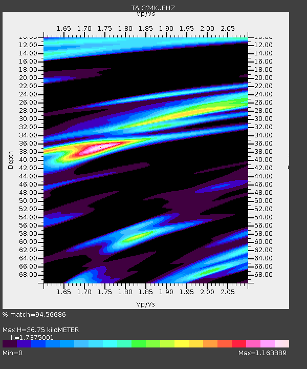
| Estimated Moho Depth: |
36.75 km |
| Estimated Crust Vp/Vs: |
1.74 |
| Assumed Crust Vp: |
6.522 km/s |
| Estimated Crust Vs: |
3.753 km/s |
| Estimated Crust Poisson's Ratio: |
0.25 |
|
| Radial Match: |
94.56686 % |
| Radial Bump: |
397 |
| Transverse Match: |
83.18355 % |
| Transverse Bump: |
400 |
| SOD ConfigId: |
11737051 |
| Insert Time: |
2019-04-25 21:10:45.030 +0000 |
| GWidth: |
2.5 |
| Max Bumps: |
400 |
| Tol: |
0.001 |
|

Signal To Noise
| Channel | StoN | STA | LTA |
| TA:G24K: :BHZ:20161021T05:16:14.47498Z | 10.431269 | 1.3216828E-6 | 1.2670394E-7 |
| TA:G24K: :BHN:20161021T05:16:14.47498Z | 1.582903 | 1.7060435E-7 | 1.0777941E-7 |
| TA:G24K: :BHE:20161021T05:16:14.47498Z | 7.00316 | 6.328123E-7 | 9.036096E-8 |
| Arrivals |
| Ps | 4.4 SECOND |
| PpPs | 15 SECOND |
| PsPs/PpSs | 19 SECOND |


