You are here: Home > Network List > TA - USArray Transportable Network (new EarthScope stations) Stations List
> Station H23K Yukon River, AK, USA > Earthquake Result Viewer
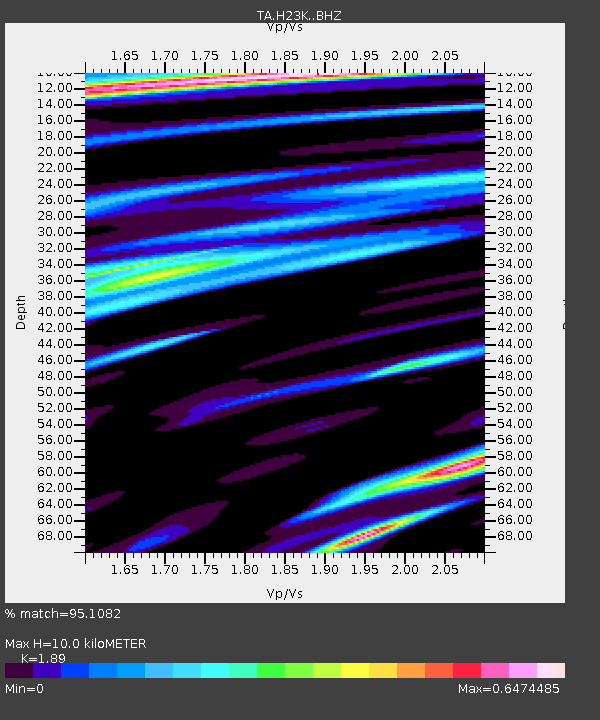
H23K Yukon River, AK, USA - Earthquake Result Viewer
| Earthquake location: |
Western Honshu, Japan |
| Earthquake latitude/longitude: |
35.4/133.8 |
| Earthquake time(UTC): |
2016/10/21 (295) 05:07:23 GMT |
| Earthquake Depth: |
10 km |
| Earthquake Magnitude: |
6.2 MWW, 6.6 MI |
| Earthquake Catalog/Contributor: |
NEIC PDE/NEIC COMCAT |
|
| Network: |
TA USArray Transportable Network (new EarthScope stations) |
| Station: |
H23K Yukon River, AK, USA |
| Lat/Lon: |
65.83 N/149.54 W |
| Elevation: |
617 m |
|
| Distance: |
52.9 deg |
| Az: |
30.141 deg |
| Baz: |
274.696 deg |
| Ray Param: |
0.06643483 |
| Estimated Moho Depth: |
10.0 km |
| Estimated Crust Vp/Vs: |
1.89 |
| Assumed Crust Vp: |
6.566 km/s |
| Estimated Crust Vs: |
3.474 km/s |
| Estimated Crust Poisson's Ratio: |
0.31 |
|
| Radial Match: |
95.1082 % |
| Radial Bump: |
381 |
| Transverse Match: |
87.73004 % |
| Transverse Bump: |
400 |
| SOD ConfigId: |
11737051 |
| Insert Time: |
2019-04-25 21:10:51.059 +0000 |
| GWidth: |
2.5 |
| Max Bumps: |
400 |
| Tol: |
0.001 |
|

Signal To Noise
| Channel | StoN | STA | LTA |
| TA:H23K: :BHZ:20161021T05:16:08.950017Z | 9.145094 | 1.1869998E-6 | 1.2979636E-7 |
| TA:H23K: :BHN:20161021T05:16:08.950017Z | 1.4895667 | 1.3321352E-7 | 8.943105E-8 |
| TA:H23K: :BHE:20161021T05:16:08.950017Z | 6.9661856 | 5.3908553E-7 | 7.738604E-8 |
| Arrivals |
| Ps | 1.4 SECOND |
| PpPs | 4.2 SECOND |
| PsPs/PpSs | 5.6 SECOND |


