You are here: Home > Network List > TA - USArray Transportable Network (new EarthScope stations) Stations List
> Station MSTX Muleshoe, TX, USA > Earthquake Result Viewer
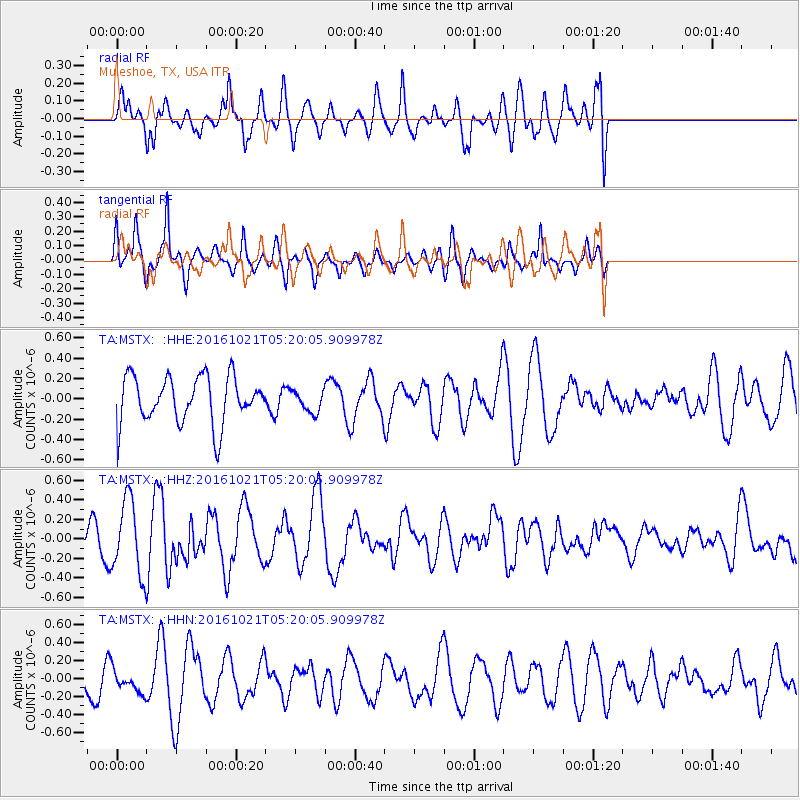
MSTX Muleshoe, TX, USA - Earthquake Result Viewer
*The percent match for this event was below the threshold and hence no stack was calculated.
| Earthquake location: |
Western Honshu, Japan |
| Earthquake latitude/longitude: |
35.4/133.8 |
| Earthquake time(UTC): |
2016/10/21 (295) 05:07:23 GMT |
| Earthquake Depth: |
10 km |
| Earthquake Magnitude: |
6.2 MWW, 6.6 MI |
| Earthquake Catalog/Contributor: |
NEIC PDE/NEIC COMCAT |
|
| Network: |
TA USArray Transportable Network (new EarthScope stations) |
| Station: |
MSTX Muleshoe, TX, USA |
| Lat/Lon: |
33.97 N/102.77 W |
| Elevation: |
1167 m |
|
| Distance: |
93.1 deg |
| Az: |
43.996 deg |
| Baz: |
316.908 deg |
| Ray Param: |
$rayparam |
*The percent match for this event was below the threshold and hence was not used in the summary stack. |
|
| Radial Match: |
54.473755 % |
| Radial Bump: |
400 |
| Transverse Match: |
62.85337 % |
| Transverse Bump: |
336 |
| SOD ConfigId: |
11737051 |
| Insert Time: |
2019-04-25 21:11:26.412 +0000 |
| GWidth: |
2.5 |
| Max Bumps: |
400 |
| Tol: |
0.001 |
|
Signal To Noise
| Channel | StoN | STA | LTA |
| TA:MSTX: :HHZ:20161021T05:20:05.909978Z | 2.4957595 | 3.7318097E-7 | 1.49526E-7 |
| TA:MSTX: :HHN:20161021T05:20:05.909978Z | 0.6381673 | 1.2185076E-7 | 1.909386E-7 |
| TA:MSTX: :HHE:20161021T05:20:05.909978Z | 0.4532033 | 1.06200424E-7 | 2.3433286E-7 |
| Arrivals |
| Ps | |
| PpPs | |
| PsPs/PpSs | |


