You are here: Home > Network List > TJ - Tajikistan National Seismic Network Stations List
> Station CHGR Chuyangaron, Tajikistan > Earthquake Result Viewer
CHGR Chuyangaron, Tajikistan - Earthquake Result Viewer
| Earthquake location: |
Western Honshu, Japan |
| Earthquake latitude/longitude: |
35.4/133.8 |
| Earthquake time(UTC): |
2016/10/21 (295) 05:07:23 GMT |
| Earthquake Depth: |
10 km |
| Earthquake Magnitude: |
6.2 MWW, 6.6 MI |
| Earthquake Catalog/Contributor: |
NEIC PDE/NEIC COMCAT |
|
| Network: |
TJ Tajikistan National Seismic Network |
| Station: |
CHGR Chuyangaron, Tajikistan |
| Lat/Lon: |
38.66 N/69.16 E |
| Elevation: |
1049 m |
|
| Distance: |
50.8 deg |
| Az: |
294.022 deg |
| Baz: |
72.472 deg |
| Ray Param: |
0.06783365 |
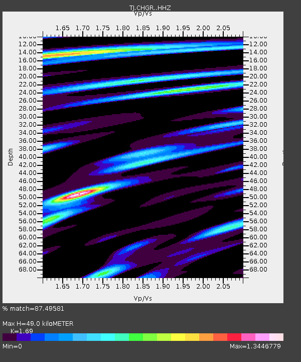
| Estimated Moho Depth: |
49.0 km |
| Estimated Crust Vp/Vs: |
1.69 |
| Assumed Crust Vp: |
6.483 km/s |
| Estimated Crust Vs: |
3.836 km/s |
| Estimated Crust Poisson's Ratio: |
0.23 |
|
| Radial Match: |
87.49581 % |
| Radial Bump: |
354 |
| Transverse Match: |
73.91151 % |
| Transverse Bump: |
400 |
| SOD ConfigId: |
11737051 |
| Insert Time: |
2019-04-25 21:12:15.619 +0000 |
| GWidth: |
2.5 |
| Max Bumps: |
400 |
| Tol: |
0.001 |
|

Signal To Noise
| Channel | StoN | STA | LTA |
| TJ:CHGR: :HHZ:20161021T05:15:52.919988Z | 14.974179 | 1.5486212E-6 | 1.0341944E-7 |
| TJ:CHGR: :HHN:20161021T05:15:52.919988Z | 1.9528518 | 2.2049875E-7 | 1.1291116E-7 |
| TJ:CHGR: :HHE:20161021T05:15:52.919988Z | 8.002696 | 6.477625E-7 | 8.0943025E-8 |
| Arrivals |
| Ps | 5.5 SECOND |
| PpPs | 19 SECOND |
| PsPs/PpSs | 25 SECOND |


