You are here: Home > Network List > TJ - Tajikistan National Seismic Network Stations List
> Station GARM Garm, Tajikistan > Earthquake Result Viewer
GARM Garm, Tajikistan - Earthquake Result Viewer
| Earthquake location: |
Western Honshu, Japan |
| Earthquake latitude/longitude: |
35.4/133.8 |
| Earthquake time(UTC): |
2016/10/21 (295) 05:07:23 GMT |
| Earthquake Depth: |
10 km |
| Earthquake Magnitude: |
6.2 MWW, 6.6 MI |
| Earthquake Catalog/Contributor: |
NEIC PDE/NEIC COMCAT |
|
| Network: |
TJ Tajikistan National Seismic Network |
| Station: |
GARM Garm, Tajikistan |
| Lat/Lon: |
39.00 N/70.32 E |
| Elevation: |
1305 m |
|
| Distance: |
49.8 deg |
| Az: |
294.101 deg |
| Baz: |
73.246 deg |
| Ray Param: |
0.068468064 |
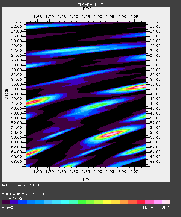
| Estimated Moho Depth: |
36.5 km |
| Estimated Crust Vp/Vs: |
2.10 |
| Assumed Crust Vp: |
6.306 km/s |
| Estimated Crust Vs: |
3.01 km/s |
| Estimated Crust Poisson's Ratio: |
0.35 |
|
| Radial Match: |
84.16023 % |
| Radial Bump: |
338 |
| Transverse Match: |
84.162094 % |
| Transverse Bump: |
400 |
| SOD ConfigId: |
11737051 |
| Insert Time: |
2019-04-25 21:12:16.005 +0000 |
| GWidth: |
2.5 |
| Max Bumps: |
400 |
| Tol: |
0.001 |
|
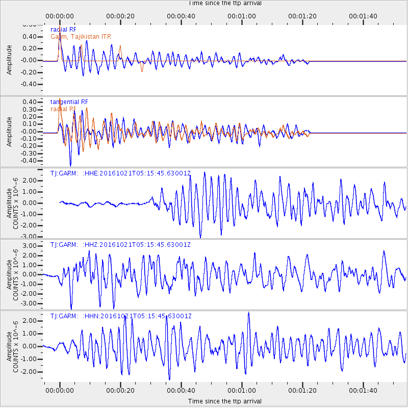
Signal To Noise
| Channel | StoN | STA | LTA |
| TJ:GARM: :HHZ:20161021T05:15:45.63001Z | 8.587808 | 1.2013459E-6 | 1.3988969E-7 |
| TJ:GARM: :HHN:20161021T05:15:45.63001Z | 2.8242135 | 3.1570215E-7 | 1.117841E-7 |
| TJ:GARM: :HHE:20161021T05:15:45.63001Z | 4.706457 | 5.1474797E-7 | 1.09370575E-7 |
| Arrivals |
| Ps | 6.6 SECOND |
| PpPs | 17 SECOND |
| PsPs/PpSs | 24 SECOND |


