You are here: Home > Network List > UW - Pacific Northwest Regional Seismic Network Stations List
> Station PASS Maple Falls, WA, USA > Earthquake Result Viewer
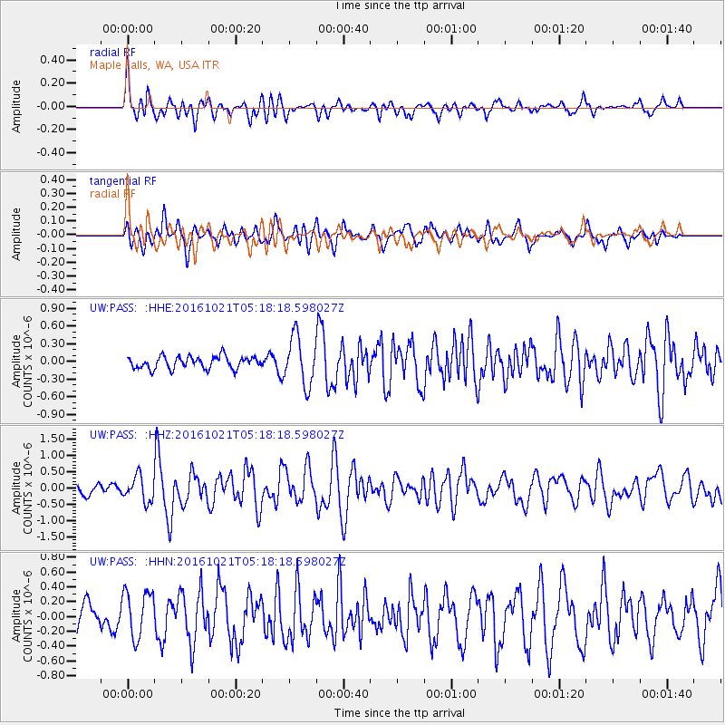
PASS Maple Falls, WA, USA - Earthquake Result Viewer
*The percent match for this event was below the threshold and hence no stack was calculated.
| Earthquake location: |
Western Honshu, Japan |
| Earthquake latitude/longitude: |
35.4/133.8 |
| Earthquake time(UTC): |
2016/10/21 (295) 05:07:23 GMT |
| Earthquake Depth: |
10 km |
| Earthquake Magnitude: |
6.2 MWW, 6.6 MI |
| Earthquake Catalog/Contributor: |
NEIC PDE/NEIC COMCAT |
|
| Network: |
UW Pacific Northwest Regional Seismic Network |
| Station: |
PASS Maple Falls, WA, USA |
| Lat/Lon: |
49.00 N/122.09 W |
| Elevation: |
174 m |
|
| Distance: |
72.4 deg |
| Az: |
42.071 deg |
| Baz: |
303.736 deg |
| Ray Param: |
$rayparam |
*The percent match for this event was below the threshold and hence was not used in the summary stack. |
|
| Radial Match: |
66.99462 % |
| Radial Bump: |
400 |
| Transverse Match: |
65.98785 % |
| Transverse Bump: |
400 |
| SOD ConfigId: |
11737051 |
| Insert Time: |
2019-04-25 21:13:29.360 +0000 |
| GWidth: |
2.5 |
| Max Bumps: |
400 |
| Tol: |
0.001 |
|
Signal To Noise
| Channel | StoN | STA | LTA |
| UW:PASS: :HHZ:20161021T05:18:18.598027Z | 2.8223522 | 3.8710837E-7 | 1.3715807E-7 |
| UW:PASS: :HHN:20161021T05:18:18.598027Z | 1.2350864 | 3.2438976E-7 | 2.626454E-7 |
| UW:PASS: :HHE:20161021T05:18:18.598027Z | 3.9301999 | 4.1182489E-7 | 1.04784725E-7 |
| Arrivals |
| Ps | |
| PpPs | |
| PsPs/PpSs | |


