You are here: Home > Network List > TA - USArray Transportable Network (new EarthScope stations) Stations List
> Station I29M Ogilvie Camp, Yukon, CA > Earthquake Result Viewer
I29M Ogilvie Camp, Yukon, CA - Earthquake Result Viewer
| Earthquake location: |
East Of Kuril Islands |
| Earthquake latitude/longitude: |
44.0/148.2 |
| Earthquake time(UTC): |
2016/10/23 (297) 20:25:26 GMT |
| Earthquake Depth: |
30 km |
| Earthquake Magnitude: |
5.8 MB |
| Earthquake Catalog/Contributor: |
NEIC PDE/NEIC COMCAT |
|
| Network: |
TA USArray Transportable Network (new EarthScope stations) |
| Station: |
I29M Ogilvie Camp, Yukon, CA |
| Lat/Lon: |
65.36 N/138.31 W |
| Elevation: |
602 m |
|
| Distance: |
44.4 deg |
| Az: |
35.047 deg |
| Baz: |
278.569 deg |
| Ray Param: |
0.07186485 |
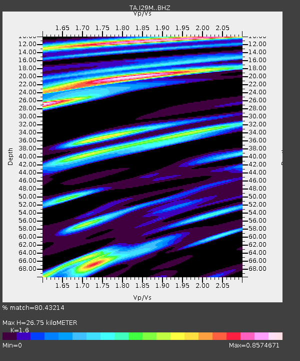
| Estimated Moho Depth: |
26.75 km |
| Estimated Crust Vp/Vs: |
1.60 |
| Assumed Crust Vp: |
6.566 km/s |
| Estimated Crust Vs: |
4.104 km/s |
| Estimated Crust Poisson's Ratio: |
0.18 |
|
| Radial Match: |
80.43214 % |
| Radial Bump: |
400 |
| Transverse Match: |
79.02281 % |
| Transverse Bump: |
400 |
| SOD ConfigId: |
11737051 |
| Insert Time: |
2019-04-25 21:31:11.483 +0000 |
| GWidth: |
2.5 |
| Max Bumps: |
400 |
| Tol: |
0.001 |
|

Signal To Noise
| Channel | StoN | STA | LTA |
| TA:I29M: :BHZ:20161023T20:33:04.499999Z | 6.2671547 | 1.3479868E-6 | 2.1508752E-7 |
| TA:I29M: :BHN:20161023T20:33:04.499999Z | 4.1455593 | 4.4872726E-7 | 1.0824287E-7 |
| TA:I29M: :BHE:20161023T20:33:04.499999Z | 3.9736166 | 6.7567066E-7 | 1.7003921E-7 |
| Arrivals |
| Ps | 2.6 SECOND |
| PpPs | 9.8 SECOND |
| PsPs/PpSs | 12 SECOND |


