You are here: Home > Network List > TA - USArray Transportable Network (new EarthScope stations) Stations List
> Station L27K Beaver Creek, Northway Junction, AK, USA > Earthquake Result Viewer
L27K Beaver Creek, Northway Junction, AK, USA - Earthquake Result Viewer

| Earthquake location: |
East Of Kuril Islands |
| Earthquake latitude/longitude: |
44.0/148.2 |
| Earthquake time(UTC): |
2016/10/23 (297) 20:25:26 GMT |
| Earthquake Depth: |
30 km |
| Earthquake Magnitude: |
5.8 MB |
| Earthquake Catalog/Contributor: |
NEIC PDE/NEIC COMCAT |
|
| Network: |
TA USArray Transportable Network (new EarthScope stations) |
| Station: |
L27K Beaver Creek, Northway Junction, AK, USA |
| Lat/Lon: |
63.06 N/141.83 W |
| Elevation: |
755 m |
|
| Distance: |
43.2 deg |
| Az: |
38.665 deg |
| Baz: |
278.012 deg |
| Ray Param: |
0.07262106 |
| Estimated Moho Depth: |
20.75 km |
| Estimated Crust Vp/Vs: |
2.09 |
| Assumed Crust Vp: |
6.566 km/s |
| Estimated Crust Vs: |
3.145 km/s |
| Estimated Crust Poisson's Ratio: |
0.35 |
|
| Radial Match: |
89.715416 % |
| Radial Bump: |
400 |
| Transverse Match: |
73.635925 % |
| Transverse Bump: |
400 |
| SOD ConfigId: |
11737051 |
| Insert Time: |
2019-04-25 21:31:22.776 +0000 |
| GWidth: |
2.5 |
| Max Bumps: |
400 |
| Tol: |
0.001 |
|
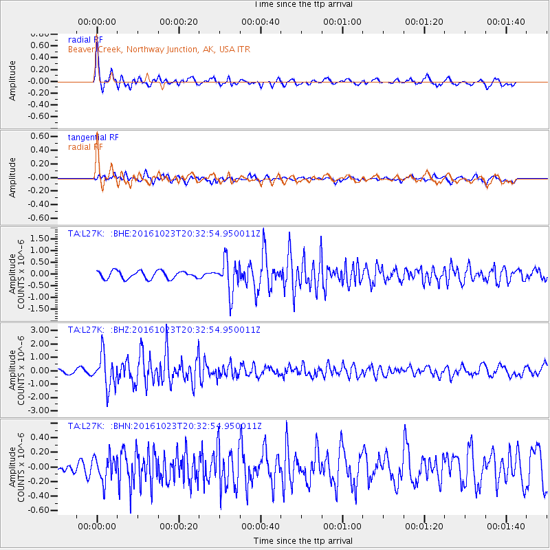
Signal To Noise
| Channel | StoN | STA | LTA |
| TA:L27K: :BHZ:20161023T20:32:54.950011Z | 8.917304 | 1.2398502E-6 | 1.3903869E-7 |
| TA:L27K: :BHN:20161023T20:32:54.950011Z | 1.7980579 | 1.7175599E-7 | 9.5523056E-8 |
| TA:L27K: :BHE:20161023T20:32:54.950011Z | 4.420399 | 7.1379304E-7 | 1.6147705E-7 |
| Arrivals |
| Ps | 3.6 SECOND |
| PpPs | 9.2 SECOND |
| PsPs/PpSs | 13 SECOND |


