You are here: Home > Network List > TA - USArray Transportable Network (new EarthScope stations) Stations List
> Station R32K Eaglecrest, AK, USA > Earthquake Result Viewer
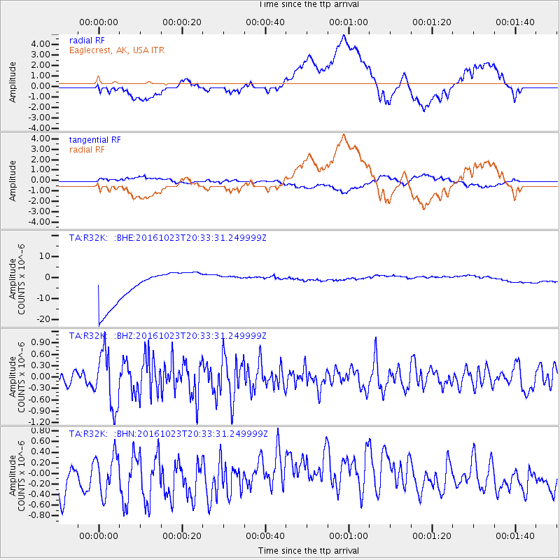
R32K Eaglecrest, AK, USA - Earthquake Result Viewer
*The percent match for this event was below the threshold and hence no stack was calculated.
| Earthquake location: |
East Of Kuril Islands |
| Earthquake latitude/longitude: |
44.0/148.2 |
| Earthquake time(UTC): |
2016/10/23 (297) 20:25:26 GMT |
| Earthquake Depth: |
30 km |
| Earthquake Magnitude: |
5.8 MB |
| Earthquake Catalog/Contributor: |
NEIC PDE/NEIC COMCAT |
|
| Network: |
TA USArray Transportable Network (new EarthScope stations) |
| Station: |
R32K Eaglecrest, AK, USA |
| Lat/Lon: |
58.27 N/134.52 W |
| Elevation: |
386 m |
|
| Distance: |
47.8 deg |
| Az: |
44.066 deg |
| Baz: |
288.169 deg |
| Ray Param: |
$rayparam |
*The percent match for this event was below the threshold and hence was not used in the summary stack. |
|
| Radial Match: |
27.982975 % |
| Radial Bump: |
400 |
| Transverse Match: |
29.024885 % |
| Transverse Bump: |
400 |
| SOD ConfigId: |
11737051 |
| Insert Time: |
2019-04-25 21:32:01.241 +0000 |
| GWidth: |
2.5 |
| Max Bumps: |
400 |
| Tol: |
0.001 |
|
Signal To Noise
| Channel | StoN | STA | LTA |
| TA:R32K: :BHZ:20161023T20:33:31.249999Z | 1.9917337 | 7.4069186E-7 | 3.7188298E-7 |
| TA:R32K: :BHN:20161023T20:33:31.249999Z | 0.83545107 | 4.416339E-7 | 5.286173E-7 |
| TA:R32K: :BHE:20161023T20:33:31.249999Z | 0.56942564 | 4.2559755E-6 | 7.474155E-6 |
| Arrivals |
| Ps | |
| PpPs | |
| PsPs/PpSs | |


