You are here: Home > Network List > TA - USArray Transportable Network (new EarthScope stations) Stations List
> Station R33M Jennings River, BC, CAN > Earthquake Result Viewer
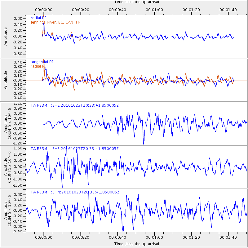
R33M Jennings River, BC, CAN - Earthquake Result Viewer
*The percent match for this event was below the threshold and hence no stack was calculated.
| Earthquake location: |
East Of Kuril Islands |
| Earthquake latitude/longitude: |
44.0/148.2 |
| Earthquake time(UTC): |
2016/10/23 (297) 20:25:26 GMT |
| Earthquake Depth: |
30 km |
| Earthquake Magnitude: |
5.8 MB |
| Earthquake Catalog/Contributor: |
NEIC PDE/NEIC COMCAT |
|
| Network: |
TA USArray Transportable Network (new EarthScope stations) |
| Station: |
R33M Jennings River, BC, CAN |
| Lat/Lon: |
59.39 N/130.97 W |
| Elevation: |
1437 m |
|
| Distance: |
49.2 deg |
| Az: |
41.848 deg |
| Baz: |
289.733 deg |
| Ray Param: |
$rayparam |
*The percent match for this event was below the threshold and hence was not used in the summary stack. |
|
| Radial Match: |
65.27675 % |
| Radial Bump: |
400 |
| Transverse Match: |
63.984882 % |
| Transverse Bump: |
400 |
| SOD ConfigId: |
11737051 |
| Insert Time: |
2019-04-25 21:32:01.374 +0000 |
| GWidth: |
2.5 |
| Max Bumps: |
400 |
| Tol: |
0.001 |
|
Signal To Noise
| Channel | StoN | STA | LTA |
| TA:R33M: :BHZ:20161023T20:33:41.850005Z | 2.8210373 | 5.8236924E-7 | 2.0643799E-7 |
| TA:R33M: :BHN:20161023T20:33:41.850005Z | 1.3658216 | 2.7465646E-7 | 2.0109249E-7 |
| TA:R33M: :BHE:20161023T20:33:41.850005Z | 1.2903191 | 1.9743406E-7 | 1.5301181E-7 |
| Arrivals |
| Ps | |
| PpPs | |
| PsPs/PpSs | |


