You are here: Home > Network List > TA - USArray Transportable Network (new EarthScope stations) Stations List
> Station S22A 4UR Ranch, Creede, CO, USA > Earthquake Result Viewer
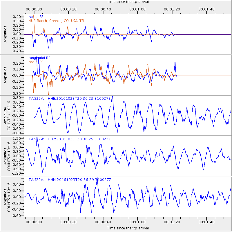
S22A 4UR Ranch, Creede, CO, USA - Earthquake Result Viewer
*The percent match for this event was below the threshold and hence no stack was calculated.
| Earthquake location: |
East Of Kuril Islands |
| Earthquake latitude/longitude: |
44.0/148.2 |
| Earthquake time(UTC): |
2016/10/23 (297) 20:25:26 GMT |
| Earthquake Depth: |
30 km |
| Earthquake Magnitude: |
5.8 MB |
| Earthquake Catalog/Contributor: |
NEIC PDE/NEIC COMCAT |
|
| Network: |
TA USArray Transportable Network (new EarthScope stations) |
| Station: |
S22A 4UR Ranch, Creede, CO, USA |
| Lat/Lon: |
37.75 N/106.83 W |
| Elevation: |
2626 m |
|
| Distance: |
74.1 deg |
| Az: |
52.755 deg |
| Baz: |
313.537 deg |
| Ray Param: |
$rayparam |
*The percent match for this event was below the threshold and hence was not used in the summary stack. |
|
| Radial Match: |
62.95588 % |
| Radial Bump: |
400 |
| Transverse Match: |
86.61195 % |
| Transverse Bump: |
400 |
| SOD ConfigId: |
11737051 |
| Insert Time: |
2019-04-25 21:32:02.981 +0000 |
| GWidth: |
2.5 |
| Max Bumps: |
400 |
| Tol: |
0.001 |
|
Signal To Noise
| Channel | StoN | STA | LTA |
| TA:S22A: :HHZ:20161023T20:36:29.310027Z | 1.9016272 | 6.681373E-7 | 3.513503E-7 |
| TA:S22A: :HHN:20161023T20:36:29.310027Z | 0.4352111 | 1.0732166E-7 | 2.4659678E-7 |
| TA:S22A: :HHE:20161023T20:36:29.310027Z | 0.96922684 | 3.3742498E-7 | 3.481383E-7 |
| Arrivals |
| Ps | |
| PpPs | |
| PsPs/PpSs | |


