You are here: Home > Network List > TJ - Tajikistan National Seismic Network Stations List
> Station CHGR Chuyangaron, Tajikistan > Earthquake Result Viewer
CHGR Chuyangaron, Tajikistan - Earthquake Result Viewer
| Earthquake location: |
East Of Kuril Islands |
| Earthquake latitude/longitude: |
44.0/148.2 |
| Earthquake time(UTC): |
2016/10/23 (297) 20:25:26 GMT |
| Earthquake Depth: |
30 km |
| Earthquake Magnitude: |
5.8 MB |
| Earthquake Catalog/Contributor: |
NEIC PDE/NEIC COMCAT |
|
| Network: |
TJ Tajikistan National Seismic Network |
| Station: |
CHGR Chuyangaron, Tajikistan |
| Lat/Lon: |
38.66 N/69.16 E |
| Elevation: |
1049 m |
|
| Distance: |
57.4 deg |
| Az: |
294.22 deg |
| Baz: |
57.231 deg |
| Ray Param: |
0.063446715 |
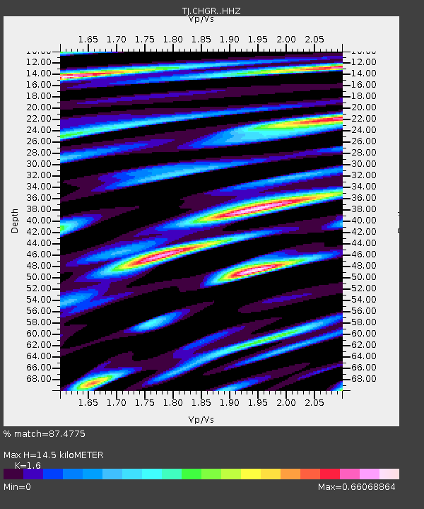
| Estimated Moho Depth: |
14.5 km |
| Estimated Crust Vp/Vs: |
1.60 |
| Assumed Crust Vp: |
6.483 km/s |
| Estimated Crust Vs: |
4.052 km/s |
| Estimated Crust Poisson's Ratio: |
0.18 |
|
| Radial Match: |
87.4775 % |
| Radial Bump: |
400 |
| Transverse Match: |
79.86547 % |
| Transverse Bump: |
400 |
| SOD ConfigId: |
11737051 |
| Insert Time: |
2019-04-25 21:32:20.034 +0000 |
| GWidth: |
2.5 |
| Max Bumps: |
400 |
| Tol: |
0.001 |
|

Signal To Noise
| Channel | StoN | STA | LTA |
| TJ:CHGR: :HHZ:20161023T20:34:42.069976Z | 40.247234 | 5.00516E-6 | 1.2436034E-7 |
| TJ:CHGR: :HHN:20161023T20:34:42.069976Z | 11.728271 | 1.3493301E-6 | 1.1504936E-7 |
| TJ:CHGR: :HHE:20161023T20:34:42.069976Z | 14.833 | 1.6035574E-6 | 1.0810742E-7 |
| Arrivals |
| Ps | 1.4 SECOND |
| PpPs | 5.5 SECOND |
| PsPs/PpSs | 6.9 SECOND |


