You are here: Home > Network List > US - United States National Seismic Network Stations List
> Station COWI Conover, Wisconsin, USA > Earthquake Result Viewer
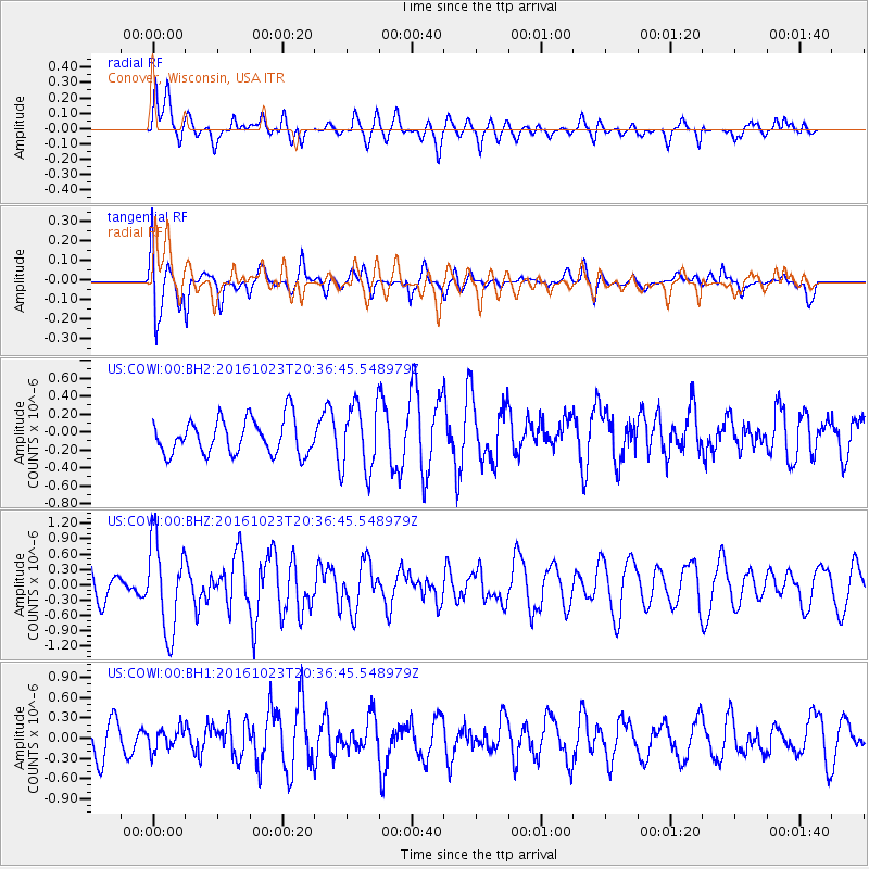
COWI Conover, Wisconsin, USA - Earthquake Result Viewer
*The percent match for this event was below the threshold and hence no stack was calculated.
| Earthquake location: |
East Of Kuril Islands |
| Earthquake latitude/longitude: |
44.0/148.2 |
| Earthquake time(UTC): |
2016/10/23 (297) 20:25:26 GMT |
| Earthquake Depth: |
30 km |
| Earthquake Magnitude: |
5.8 MB |
| Earthquake Catalog/Contributor: |
NEIC PDE/NEIC COMCAT |
|
| Network: |
US United States National Seismic Network |
| Station: |
COWI Conover, Wisconsin, USA |
| Lat/Lon: |
46.10 N/89.14 W |
| Elevation: |
523 m |
|
| Distance: |
77.0 deg |
| Az: |
36.943 deg |
| Baz: |
321.424 deg |
| Ray Param: |
$rayparam |
*The percent match for this event was below the threshold and hence was not used in the summary stack. |
|
| Radial Match: |
64.674835 % |
| Radial Bump: |
400 |
| Transverse Match: |
67.64264 % |
| Transverse Bump: |
400 |
| SOD ConfigId: |
11737051 |
| Insert Time: |
2019-04-25 21:32:50.741 +0000 |
| GWidth: |
2.5 |
| Max Bumps: |
400 |
| Tol: |
0.001 |
|
Signal To Noise
| Channel | StoN | STA | LTA |
| US:COWI:00:BHZ:20161023T20:36:45.548979Z | 3.0300343 | 8.8441124E-7 | 2.918816E-7 |
| US:COWI:00:BH1:20161023T20:36:45.548979Z | 0.6654291 | 1.6154809E-7 | 2.4277278E-7 |
| US:COWI:00:BH2:20161023T20:36:45.548979Z | 1.9384767 | 3.7600773E-7 | 1.9397072E-7 |
| Arrivals |
| Ps | |
| PpPs | |
| PsPs/PpSs | |


