You are here: Home > Network List > TA - USArray Transportable Network (new EarthScope stations) Stations List
> Station R32K Eaglecrest, AK, USA > Earthquake Result Viewer
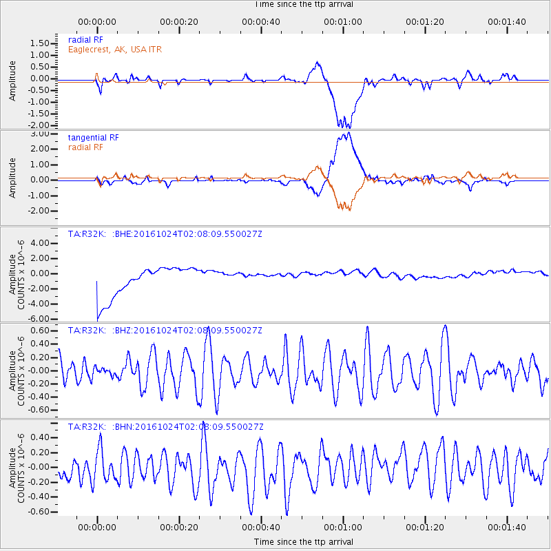
R32K Eaglecrest, AK, USA - Earthquake Result Viewer
*The percent match for this event was below the threshold and hence no stack was calculated.
| Earthquake location: |
Southeast Of Easter Island |
| Earthquake latitude/longitude: |
-36.0/-102.7 |
| Earthquake time(UTC): |
2016/10/24 (298) 01:55:06 GMT |
| Earthquake Depth: |
10 km |
| Earthquake Magnitude: |
5.5 Mwb |
| Earthquake Catalog/Contributor: |
NEIC PDE/us |
|
| Network: |
TA USArray Transportable Network (new EarthScope stations) |
| Station: |
R32K Eaglecrest, AK, USA |
| Lat/Lon: |
58.27 N/134.52 W |
| Elevation: |
386 m |
|
| Distance: |
97.6 deg |
| Az: |
343.67 deg |
| Baz: |
154.438 deg |
| Ray Param: |
$rayparam |
*The percent match for this event was below the threshold and hence was not used in the summary stack. |
|
| Radial Match: |
24.10634 % |
| Radial Bump: |
400 |
| Transverse Match: |
16.734858 % |
| Transverse Bump: |
400 |
| SOD ConfigId: |
11737051 |
| Insert Time: |
2019-04-25 21:48:00.195 +0000 |
| GWidth: |
2.5 |
| Max Bumps: |
400 |
| Tol: |
0.001 |
|
Signal To Noise
| Channel | StoN | STA | LTA |
| TA:R32K: :BHZ:20161024T02:08:09.550027Z | 0.28438762 | 5.1454773E-8 | 1.8093183E-7 |
| TA:R32K: :BHN:20161024T02:08:09.550027Z | 0.71672815 | 2.481746E-7 | 3.462604E-7 |
| TA:R32K: :BHE:20161024T02:08:09.550027Z | 0.4541395 | 8.874083E-7 | 1.9540432E-6 |
| Arrivals |
| Ps | |
| PpPs | |
| PsPs/PpSs | |


