You are here: Home > Network List > YH16 - Play Fairway Analysis - Passive monitoring of St. Helens Shear zone for tomograp Stations List
> Station MF00 Toutle, WA, USA > Earthquake Result Viewer
MF00 Toutle, WA, USA - Earthquake Result Viewer
| Earthquake location: |
Southeast Of Easter Island |
| Earthquake latitude/longitude: |
-36.0/-102.7 |
| Earthquake time(UTC): |
2016/10/24 (298) 01:55:06 GMT |
| Earthquake Depth: |
10 km |
| Earthquake Magnitude: |
5.5 Mwb |
| Earthquake Catalog/Contributor: |
NEIC PDE/us |
|
| Network: |
YH Play Fairway Analysis - Passive monitoring of St. Helens Shear zone for tomograp |
| Station: |
MF00 Toutle, WA, USA |
| Lat/Lon: |
46.35 N/122.24 W |
| Elevation: |
1221 m |
|
| Distance: |
83.8 deg |
| Az: |
346.515 deg |
| Baz: |
164.159 deg |
| Ray Param: |
0.045898132 |
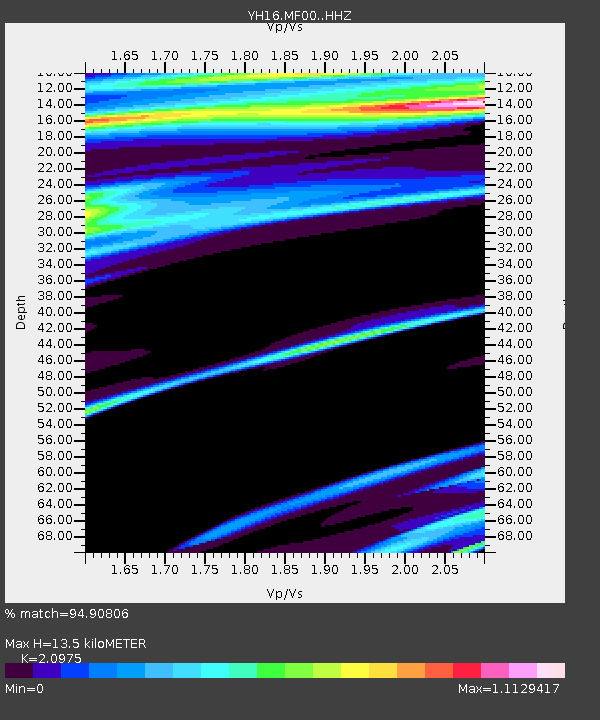
| Estimated Moho Depth: |
13.5 km |
| Estimated Crust Vp/Vs: |
2.10 |
| Assumed Crust Vp: |
6.566 km/s |
| Estimated Crust Vs: |
3.13 km/s |
| Estimated Crust Poisson's Ratio: |
0.35 |
|
| Radial Match: |
94.90806 % |
| Radial Bump: |
400 |
| Transverse Match: |
90.406136 % |
| Transverse Bump: |
399 |
| SOD ConfigId: |
11737051 |
| Insert Time: |
2019-04-25 21:50:32.607 +0000 |
| GWidth: |
2.5 |
| Max Bumps: |
400 |
| Tol: |
0.001 |
|

Signal To Noise
| Channel | StoN | STA | LTA |
| YH:MF00: :HHZ:20161024T02:07:04.874978Z | 2.7666929 | 1.1599774E-6 | 4.1926495E-7 |
| YH:MF00: :HHN:20161024T02:07:04.874978Z | 4.792858 | 2.758763E-6 | 5.7559873E-7 |
| YH:MF00: :HHE:20161024T02:07:04.874978Z | 0.5532265 | 2.9771144E-7 | 5.3813665E-7 |
| Arrivals |
| Ps | 2.3 SECOND |
| PpPs | 6.2 SECOND |
| PsPs/PpSs | 8.5 SECOND |


