You are here: Home > Network List > BK - Berkeley Digital Seismograph Network Stations List
> Station CMB Columbia College, Columbia, CA > Earthquake Result Viewer
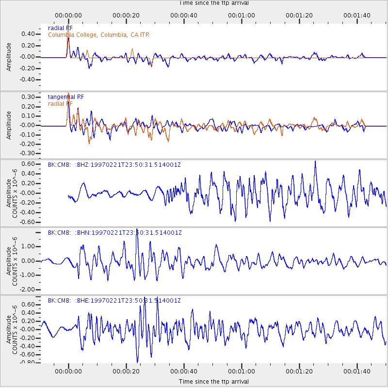
CMB Columbia College, Columbia, CA - Earthquake Result Viewer
*The percent match for this event was below the threshold and hence no stack was calculated.
| Earthquake location: |
East Of Kuril Islands |
| Earthquake latitude/longitude: |
43.8/149.2 |
| Earthquake time(UTC): |
1997/02/21 (052) 23:40:24 GMT |
| Earthquake Depth: |
33 km |
| Earthquake Magnitude: |
6.1 MB, 5.6 MS, 6.1 UNKNOWN, 6.1 MW |
| Earthquake Catalog/Contributor: |
WHDF/NEIC |
|
| Network: |
BK Berkeley Digital Seismograph Network |
| Station: |
CMB Columbia College, Columbia, CA |
| Lat/Lon: |
38.03 N/120.39 W |
| Elevation: |
697 m |
|
| Distance: |
65.2 deg |
| Az: |
60.414 deg |
| Baz: |
307.153 deg |
| Ray Param: |
$rayparam |
*The percent match for this event was below the threshold and hence was not used in the summary stack. |
|
| Radial Match: |
85.62709 % |
| Radial Bump: |
400 |
| Transverse Match: |
74.435394 % |
| Transverse Bump: |
400 |
| SOD ConfigId: |
4480 |
| Insert Time: |
2010-03-05 19:04:40.458 +0000 |
| GWidth: |
2.5 |
| Max Bumps: |
400 |
| Tol: |
0.001 |
|
Signal To Noise
| Channel | StoN | STA | LTA |
| BK:CMB: :BHN:19970221T23:50:31.514001Z | 5.6881523 | 5.174697E-7 | 9.0973245E-8 |
| BK:CMB: :BHE:19970221T23:50:31.514001Z | 1.6034003 | 1.781725E-7 | 1.1112165E-7 |
| BK:CMB: :BHZ:19970221T23:50:31.514001Z | 1.5061506 | 1.12621315E-7 | 7.477427E-8 |
| Arrivals |
| Ps | |
| PpPs | |
| PsPs/PpSs | |


