You are here: Home > Network List > UW - Pacific Northwest Regional Seismic Network Stations List
> Station LEBA Lebam, WA, USA > Earthquake Result Viewer
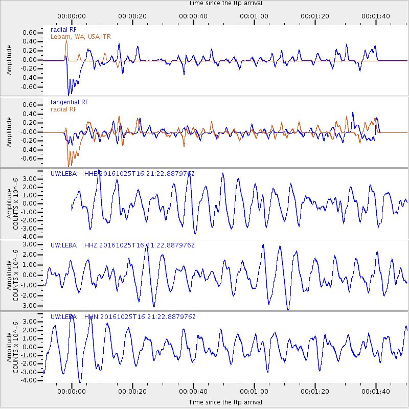
LEBA Lebam, WA, USA - Earthquake Result Viewer
*The percent match for this event was below the threshold and hence no stack was calculated.
| Earthquake location: |
Tonga Islands |
| Earthquake latitude/longitude: |
-15.4/-174.8 |
| Earthquake time(UTC): |
2016/10/25 (299) 16:10:01 GMT |
| Earthquake Depth: |
0.0 km |
| Earthquake Magnitude: |
5.8 |
| Earthquake Catalog/Contributor: |
NEIC PDE/us |
|
| Network: |
UW Pacific Northwest Regional Seismic Network |
| Station: |
LEBA Lebam, WA, USA |
| Lat/Lon: |
46.55 N/123.56 W |
| Elevation: |
73 m |
|
| Distance: |
77.0 deg |
| Az: |
33.55 deg |
| Baz: |
230.568 deg |
| Ray Param: |
$rayparam |
*The percent match for this event was below the threshold and hence was not used in the summary stack. |
|
| Radial Match: |
41.189762 % |
| Radial Bump: |
400 |
| Transverse Match: |
36.654446 % |
| Transverse Bump: |
400 |
| SOD ConfigId: |
11737051 |
| Insert Time: |
2019-04-25 22:00:47.154 +0000 |
| GWidth: |
2.5 |
| Max Bumps: |
400 |
| Tol: |
0.001 |
|
Signal To Noise
| Channel | StoN | STA | LTA |
| UW:LEBA: :HHZ:20161025T16:21:22.887976Z | 1.2799813 | 1.0289647E-6 | 8.038904E-7 |
| UW:LEBA: :HHN:20161025T16:21:22.887976Z | 2.112679 | 2.7172914E-6 | 1.2861829E-6 |
| UW:LEBA: :HHE:20161025T16:21:22.887976Z | 1.0794033 | 1.657482E-6 | 1.5355539E-6 |
| Arrivals |
| Ps | |
| PpPs | |
| PsPs/PpSs | |


