You are here: Home > Network List > YT07 - POLENET Stations List
> Station MPAT MPAT > Earthquake Result Viewer
MPAT MPAT - Earthquake Result Viewer
| Earthquake location: |
Tonga Islands |
| Earthquake latitude/longitude: |
-15.5/-174.9 |
| Earthquake time(UTC): |
2016/10/26 (300) 05:19:50 GMT |
| Earthquake Depth: |
10 km |
| Earthquake Magnitude: |
6.1 MWW, 6.1 MWC |
| Earthquake Catalog/Contributor: |
NEIC PDE/NEIC COMCAT |
|
| Network: |
YT POLENET |
| Station: |
MPAT MPAT |
| Lat/Lon: |
78.03 S/155.02 W |
| Elevation: |
540 m |
|
| Distance: |
63.3 deg |
| Az: |
175.448 deg |
| Baz: |
338.504 deg |
| Ray Param: |
0.059679363 |
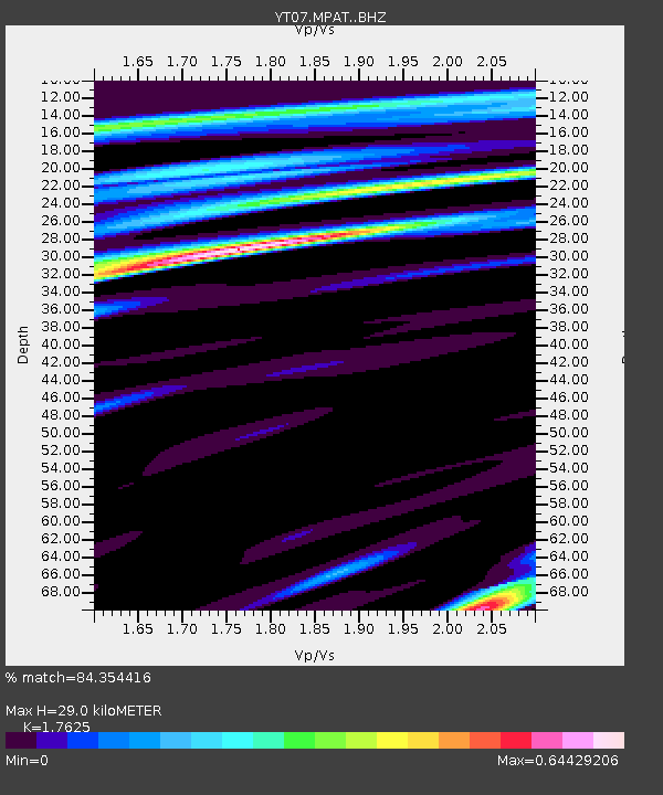
| Estimated Moho Depth: |
29.0 km |
| Estimated Crust Vp/Vs: |
1.76 |
| Assumed Crust Vp: |
6.43 km/s |
| Estimated Crust Vs: |
3.648 km/s |
| Estimated Crust Poisson's Ratio: |
0.26 |
|
| Radial Match: |
84.354416 % |
| Radial Bump: |
400 |
| Transverse Match: |
71.014824 % |
| Transverse Bump: |
400 |
| SOD ConfigId: |
11737051 |
| Insert Time: |
2019-04-25 22:11:10.323 +0000 |
| GWidth: |
2.5 |
| Max Bumps: |
400 |
| Tol: |
0.001 |
|

Signal To Noise
| Channel | StoN | STA | LTA |
| YT:MPAT: :BHZ:20161026T05:29:48.150015Z | 9.401113 | 4.0471141E-7 | 4.304931E-8 |
| YT:MPAT: :BHN:20161026T05:29:48.150015Z | 2.9578922 | 2.2823535E-7 | 7.716148E-8 |
| YT:MPAT: :BHE:20161026T05:29:48.150015Z | 2.03948 | 8.432917E-8 | 4.134837E-8 |
| Arrivals |
| Ps | 3.6 SECOND |
| PpPs | 12 SECOND |
| PsPs/PpSs | 16 SECOND |


