You are here: Home > Network List > US - United States National Seismic Network Stations List
> Station DGMT Dagmar, Montana, USA > Earthquake Result Viewer
DGMT Dagmar, Montana, USA - Earthquake Result Viewer
*The percent match for this event was below the threshold and hence no stack was calculated.
| Earthquake location: |
Turkmenistan |
| Earthquake latitude/longitude: |
39.5/54.5 |
| Earthquake time(UTC): |
2016/10/26 (300) 14:15:40 GMT |
| Earthquake Depth: |
0.0 km |
| Earthquake Magnitude: |
5.4 |
| Earthquake Catalog/Contributor: |
NEIC PDE/us |
|
| Network: |
US United States National Seismic Network |
| Station: |
DGMT Dagmar, Montana, USA |
| Lat/Lon: |
48.47 N/104.20 W |
| Elevation: |
0.0 m |
|
| Distance: |
90.4 deg |
| Az: |
346.013 deg |
| Baz: |
16.324 deg |
| Ray Param: |
$rayparam |
*The percent match for this event was below the threshold and hence was not used in the summary stack. |
|
| Radial Match: |
55.547615 % |
| Radial Bump: |
400 |
| Transverse Match: |
54.10759 % |
| Transverse Bump: |
324 |
| SOD ConfigId: |
11737051 |
| Insert Time: |
2019-04-25 22:18:34.692 +0000 |
| GWidth: |
2.5 |
| Max Bumps: |
400 |
| Tol: |
0.001 |
|
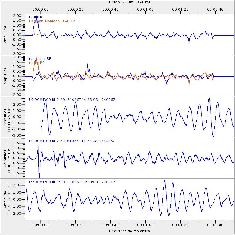
Signal To Noise
| Channel | StoN | STA | LTA |
| US:DGMT:00:BHZ:20161026T14:28:08.174026Z | 2.3835661 | 5.821173E-7 | 2.4422118E-7 |
| US:DGMT:00:BH1:20161026T14:28:08.174026Z | 0.87471926 | 8.2188E-7 | 9.395929E-7 |
| US:DGMT:00:BH2:20161026T14:28:08.174026Z | 0.78393793 | 1.079481E-6 | 1.3769981E-6 |
| Arrivals |
| Ps | |
| PpPs | |
| PsPs/PpSs | |


