You are here: Home > Network List > BK - Berkeley Digital Seismograph Network Stations List
> Station CMB Columbia College, California, USA > Earthquake Result Viewer
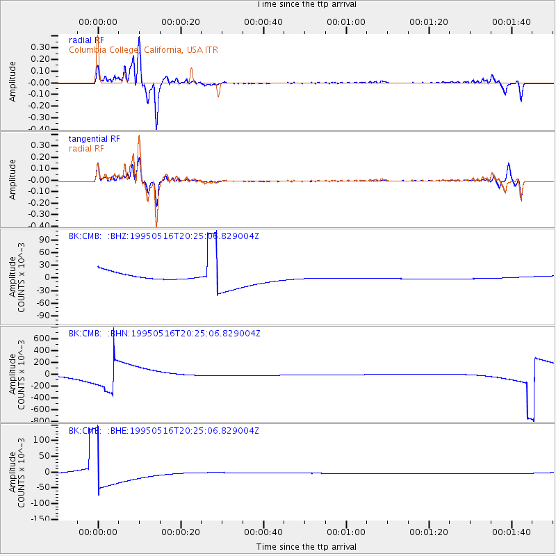
CMB Columbia College, California, USA - Earthquake Result Viewer
*The percent match for this event was below the threshold and hence no stack was calculated.
| Earthquake location: |
Southeast Of Loyalty Islands |
| Earthquake latitude/longitude: |
-23.0/169.9 |
| Earthquake time(UTC): |
1995/05/16 (136) 20:12:45 GMT |
| Earthquake Depth: |
33 km |
| Earthquake Magnitude: |
6.8 MB, 7.7 MS, 7.7 UNKNOWN, 7.7 MW |
| Earthquake Catalog/Contributor: |
WHDF/NEIC |
|
| Network: |
BK Berkeley Digital Seismograph Network |
| Station: |
CMB Columbia College, California, USA |
| Lat/Lon: |
38.03 N/120.39 W |
| Elevation: |
719 m |
|
| Distance: |
89.2 deg |
| Az: |
47.797 deg |
| Baz: |
239.806 deg |
| Ray Param: |
$rayparam |
*The percent match for this event was below the threshold and hence was not used in the summary stack. |
|
| Radial Match: |
65.92834 % |
| Radial Bump: |
330 |
| Transverse Match: |
69.47173 % |
| Transverse Bump: |
400 |
| SOD ConfigId: |
4480 |
| Insert Time: |
2010-03-05 19:07:06.217 +0000 |
| GWidth: |
2.5 |
| Max Bumps: |
400 |
| Tol: |
0.001 |
|
Signal To Noise
| Channel | StoN | STA | LTA |
| BK:CMB: :BHN:19950516T20:25:06.829004Z | 11.150667 | 0.25300127 | 0.022689339 |
| BK:CMB: :BHE:19950516T20:25:06.829004Z | 27.500795 | 0.072288826 | 0.0026286086 |
| BK:CMB: :BHZ:19950516T20:25:06.829004Z | 4.161956 | 0.034908824 | 0.008387601 |
| Arrivals |
| Ps | |
| PpPs | |
| PsPs/PpSs | |


