You are here: Home > Network List > TJ - Tajikistan National Seismic Network Stations List
> Station GARM Garm, Tajikistan > Earthquake Result Viewer
GARM Garm, Tajikistan - Earthquake Result Viewer
| Earthquake location: |
Central Italy |
| Earthquake latitude/longitude: |
42.9/13.0 |
| Earthquake time(UTC): |
2016/10/26 (300) 17:10:37 GMT |
| Earthquake Depth: |
10 km |
| Earthquake Magnitude: |
5.5 MWW |
| Earthquake Catalog/Contributor: |
NEIC PDE/NEIC COMCAT |
|
| Network: |
TJ Tajikistan National Seismic Network |
| Station: |
GARM Garm, Tajikistan |
| Lat/Lon: |
39.00 N/70.32 E |
| Elevation: |
1305 m |
|
| Distance: |
42.7 deg |
| Az: |
75.012 deg |
| Baz: |
294.275 deg |
| Ray Param: |
0.07299142 |
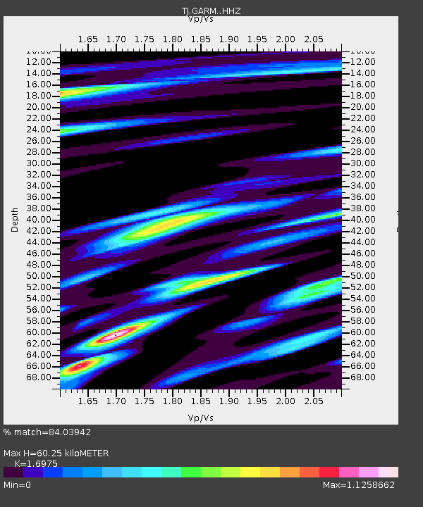
| Estimated Moho Depth: |
60.25 km |
| Estimated Crust Vp/Vs: |
1.70 |
| Assumed Crust Vp: |
6.306 km/s |
| Estimated Crust Vs: |
3.715 km/s |
| Estimated Crust Poisson's Ratio: |
0.23 |
|
| Radial Match: |
84.03942 % |
| Radial Bump: |
358 |
| Transverse Match: |
75.02096 % |
| Transverse Bump: |
400 |
| SOD ConfigId: |
11737051 |
| Insert Time: |
2019-04-25 22:29:28.002 +0000 |
| GWidth: |
2.5 |
| Max Bumps: |
400 |
| Tol: |
0.001 |
|

Signal To Noise
| Channel | StoN | STA | LTA |
| TJ:GARM: :HHZ:20161026T17:18:04.360011Z | 5.6044436 | 6.1983144E-7 | 1.1059643E-7 |
| TJ:GARM: :HHN:20161026T17:18:04.360011Z | 0.9846961 | 8.38238E-8 | 8.512657E-8 |
| TJ:GARM: :HHE:20161026T17:18:04.360011Z | 2.5958343 | 2.5697236E-7 | 9.8994136E-8 |
| Arrivals |
| Ps | 7.1 SECOND |
| PpPs | 24 SECOND |
| PsPs/PpSs | 31 SECOND |


