You are here: Home > Network List > GS - US Geological Survey Networks Stations List
> Station DEC05 Decatur Surface Seismic Site, Decatur, IL, USA > Earthquake Result Viewer
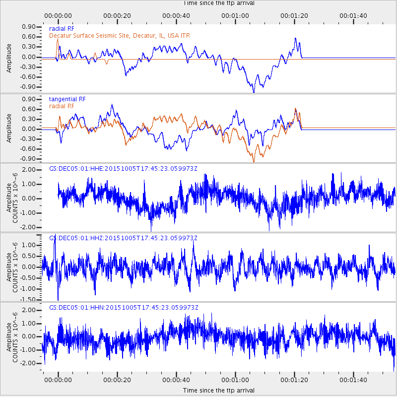
DEC05 Decatur Surface Seismic Site, Decatur, IL, USA - Earthquake Result Viewer
*The percent match for this event was below the threshold and hence no stack was calculated.
| Earthquake location: |
Andreanof Islands, Aleutian Is. |
| Earthquake latitude/longitude: |
51.9/-179.3 |
| Earthquake time(UTC): |
2015/10/05 (278) 17:35:55 GMT |
| Earthquake Depth: |
89 km |
| Earthquake Magnitude: |
5.7 MB |
| Earthquake Catalog/Contributor: |
NEIC PDE/NEIC ALERT |
|
| Network: |
GS US Geological Survey Networks |
| Station: |
DEC05 Decatur Surface Seismic Site, Decatur, IL, USA |
| Lat/Lon: |
39.87 N/88.87 W |
| Elevation: |
216 m |
|
| Distance: |
60.2 deg |
| Az: |
62.527 deg |
| Baz: |
314.419 deg |
| Ray Param: |
$rayparam |
*The percent match for this event was below the threshold and hence was not used in the summary stack. |
|
| Radial Match: |
22.464207 % |
| Radial Bump: |
400 |
| Transverse Match: |
21.965675 % |
| Transverse Bump: |
400 |
| SOD ConfigId: |
1156111 |
| Insert Time: |
2015-10-19 18:34:08.826 +0000 |
| GWidth: |
2.5 |
| Max Bumps: |
400 |
| Tol: |
0.001 |
|
Signal To Noise
| Channel | StoN | STA | LTA |
| GS:DEC05:01:HHZ:20151005T17:45:23.059973Z | 1.9082236 | 5.1210156E-7 | 2.683656E-7 |
| GS:DEC05:01:HHN:20151005T17:45:23.059973Z | 0.91180444 | 1.1328999E-6 | 1.2424812E-6 |
| GS:DEC05:01:HHE:20151005T17:45:23.059973Z | 2.6238112 | 1.1528933E-6 | 4.3939644E-7 |
| Arrivals |
| Ps | |
| PpPs | |
| PsPs/PpSs | |


