You are here: Home > Network List > IU - Global Seismograph Network (GSN - IRIS/USGS) Stations List
> Station SBA Scott Base, Antarctica > Earthquake Result Viewer
SBA Scott Base, Antarctica - Earthquake Result Viewer
| Earthquake location: |
Samoa Islands Region |
| Earthquake latitude/longitude: |
-16.4/-172.0 |
| Earthquake time(UTC): |
2009/10/17 (290) 10:45:26 GMT |
| Earthquake Depth: |
10 km |
| Earthquake Magnitude: |
5.7 MB, 5.3 MS, 5.7 MW, 5.7 MW |
| Earthquake Catalog/Contributor: |
WHDF/NEIC |
|
| Network: |
IU Global Seismograph Network (GSN - IRIS/USGS) |
| Station: |
SBA Scott Base, Antarctica |
| Lat/Lon: |
77.85 S/166.76 E |
| Elevation: |
50 m |
|
| Distance: |
62.4 deg |
| Az: |
184.971 deg |
| Baz: |
23.122 deg |
| Ray Param: |
0.060246963 |
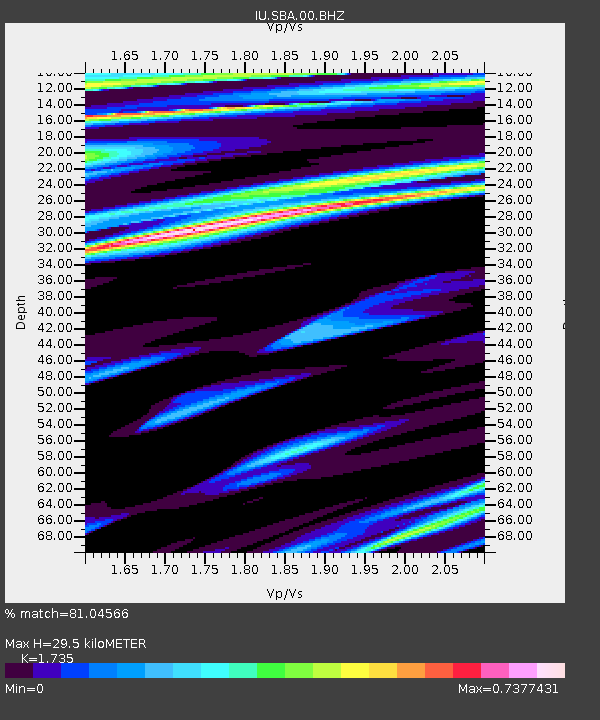
| Estimated Moho Depth: |
29.5 km |
| Estimated Crust Vp/Vs: |
1.74 |
| Assumed Crust Vp: |
6.183 km/s |
| Estimated Crust Vs: |
3.563 km/s |
| Estimated Crust Poisson's Ratio: |
0.25 |
|
| Radial Match: |
81.04566 % |
| Radial Bump: |
400 |
| Transverse Match: |
62.532658 % |
| Transverse Bump: |
376 |
| SOD ConfigId: |
1 |
| Insert Time: |
2010-02-19 00:51:26.010 +0000 |
| GWidth: |
2.5 |
| Max Bumps: |
400 |
| Tol: |
0.001 |
|
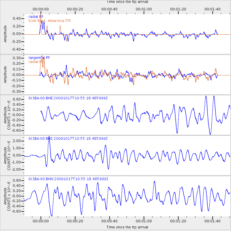
Signal To Noise
| Channel | StoN | STA | LTA |
| IU:SBA:00:BHZ:20091017T10:55:18.485999Z | 9.1079445 | 9.523251E-7 | 1.04559824E-7 |
| IU:SBA:00:BHN:20091017T10:55:18.485999Z | 2.4079351 | 2.5693305E-7 | 1.0670264E-7 |
| IU:SBA:00:BHE:20091017T10:55:18.485999Z | 1.1367276 | 1.4113512E-7 | 1.2415914E-7 |
| Arrivals |
| Ps | 3.7 SECOND |
| PpPs | 13 SECOND |
| PsPs/PpSs | 16 SECOND |


