You are here: Home > Network List > TA - USArray Transportable Network (new EarthScope stations) Stations List
> Station G21K Allakaket, AK, USA > Earthquake Result Viewer
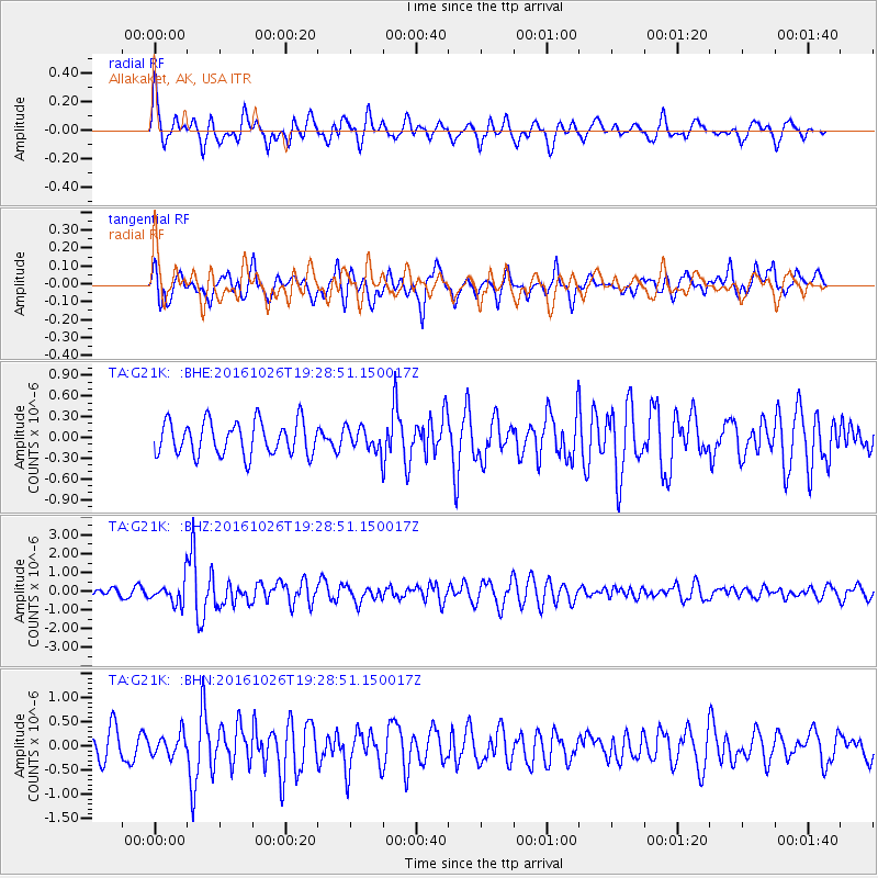
G21K Allakaket, AK, USA - Earthquake Result Viewer
*The percent match for this event was below the threshold and hence no stack was calculated.
| Earthquake location: |
Central Italy |
| Earthquake latitude/longitude: |
42.9/13.0 |
| Earthquake time(UTC): |
2016/10/26 (300) 19:18:08 GMT |
| Earthquake Depth: |
10 km |
| Earthquake Magnitude: |
6.1 MWW, 6.0 MWB, 6.1 MWR |
| Earthquake Catalog/Contributor: |
NEIC PDE/NEIC COMCAT |
|
| Network: |
TA USArray Transportable Network (new EarthScope stations) |
| Station: |
G21K Allakaket, AK, USA |
| Lat/Lon: |
66.52 N/153.51 W |
| Elevation: |
446 m |
|
| Distance: |
70.4 deg |
| Az: |
354.321 deg |
| Baz: |
10.448 deg |
| Ray Param: |
$rayparam |
*The percent match for this event was below the threshold and hence was not used in the summary stack. |
|
| Radial Match: |
72.11123 % |
| Radial Bump: |
400 |
| Transverse Match: |
69.85624 % |
| Transverse Bump: |
400 |
| SOD ConfigId: |
11737051 |
| Insert Time: |
2019-04-25 22:40:59.701 +0000 |
| GWidth: |
2.5 |
| Max Bumps: |
400 |
| Tol: |
0.001 |
|
Signal To Noise
| Channel | StoN | STA | LTA |
| TA:G21K: :BHZ:20161026T19:28:51.150017Z | 3.7436633 | 6.0025013E-7 | 1.6033763E-7 |
| TA:G21K: :BHN:20161026T19:28:51.150017Z | 0.8597167 | 2.2077127E-7 | 2.5679537E-7 |
| TA:G21K: :BHE:20161026T19:28:51.150017Z | 0.6788094 | 1.648717E-7 | 2.4288363E-7 |
| Arrivals |
| Ps | |
| PpPs | |
| PsPs/PpSs | |


