You are here: Home > Network List > TA - USArray Transportable Network (new EarthScope stations) Stations List
> Station M53A WI Miller and Sons, Farmdale, OH, USA > Earthquake Result Viewer
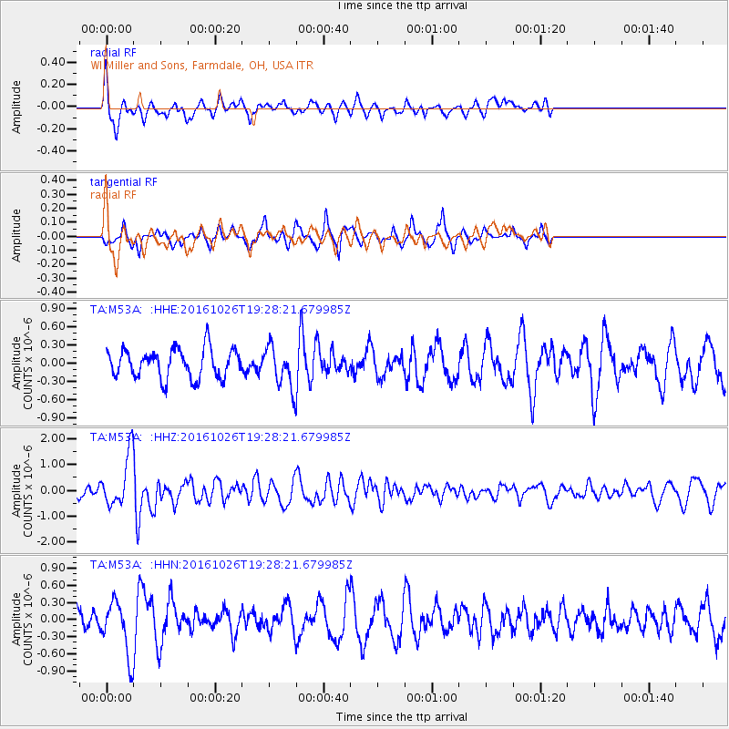
M53A WI Miller and Sons, Farmdale, OH, USA - Earthquake Result Viewer
*The percent match for this event was below the threshold and hence no stack was calculated.
| Earthquake location: |
Central Italy |
| Earthquake latitude/longitude: |
42.9/13.0 |
| Earthquake time(UTC): |
2016/10/26 (300) 19:18:08 GMT |
| Earthquake Depth: |
10 km |
| Earthquake Magnitude: |
6.1 MWW, 6.0 MWB, 6.1 MWR |
| Earthquake Catalog/Contributor: |
NEIC PDE/NEIC COMCAT |
|
| Network: |
TA USArray Transportable Network (new EarthScope stations) |
| Station: |
M53A WI Miller and Sons, Farmdale, OH, USA |
| Lat/Lon: |
41.44 N/80.68 W |
| Elevation: |
334 m |
|
| Distance: |
65.7 deg |
| Az: |
304.586 deg |
| Baz: |
53.53 deg |
| Ray Param: |
$rayparam |
*The percent match for this event was below the threshold and hence was not used in the summary stack. |
|
| Radial Match: |
61.42838 % |
| Radial Bump: |
369 |
| Transverse Match: |
70.602486 % |
| Transverse Bump: |
299 |
| SOD ConfigId: |
11737051 |
| Insert Time: |
2019-04-25 22:41:24.514 +0000 |
| GWidth: |
2.5 |
| Max Bumps: |
400 |
| Tol: |
0.001 |
|
Signal To Noise
| Channel | StoN | STA | LTA |
| TA:M53A: :HHZ:20161026T19:28:21.679985Z | 3.9050927 | 9.892087E-7 | 2.533125E-7 |
| TA:M53A: :HHN:20161026T19:28:21.679985Z | 2.1594646 | 4.6825693E-7 | 2.1683937E-7 |
| TA:M53A: :HHE:20161026T19:28:21.679985Z | 1.4151137 | 3.353221E-7 | 2.3695773E-7 |
| Arrivals |
| Ps | |
| PpPs | |
| PsPs/PpSs | |


