You are here: Home > Network List > TA - USArray Transportable Network (new EarthScope stations) Stations List
> Station N23A Red Feather Lakes, CO, USA > Earthquake Result Viewer
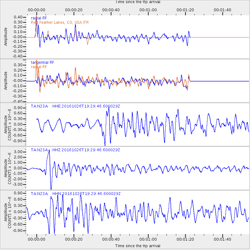
N23A Red Feather Lakes, CO, USA - Earthquake Result Viewer
*The percent match for this event was below the threshold and hence no stack was calculated.
| Earthquake location: |
Central Italy |
| Earthquake latitude/longitude: |
42.9/13.0 |
| Earthquake time(UTC): |
2016/10/26 (300) 19:18:08 GMT |
| Earthquake Depth: |
10 km |
| Earthquake Magnitude: |
6.1 MWW, 6.0 MWB, 6.1 MWR |
| Earthquake Catalog/Contributor: |
NEIC PDE/NEIC COMCAT |
|
| Network: |
TA USArray Transportable Network (new EarthScope stations) |
| Station: |
N23A Red Feather Lakes, CO, USA |
| Lat/Lon: |
40.89 N/105.94 W |
| Elevation: |
2458 m |
|
| Distance: |
80.0 deg |
| Az: |
317.682 deg |
| Baz: |
40.709 deg |
| Ray Param: |
$rayparam |
*The percent match for this event was below the threshold and hence was not used in the summary stack. |
|
| Radial Match: |
74.79783 % |
| Radial Bump: |
400 |
| Transverse Match: |
65.66582 % |
| Transverse Bump: |
400 |
| SOD ConfigId: |
11737051 |
| Insert Time: |
2019-04-25 22:41:27.561 +0000 |
| GWidth: |
2.5 |
| Max Bumps: |
400 |
| Tol: |
0.001 |
|
Signal To Noise
| Channel | StoN | STA | LTA |
| TA:N23A: :HHZ:20161026T19:29:46.600029Z | 2.459662 | 3.239151E-7 | 1.316909E-7 |
| TA:N23A: :HHN:20161026T19:29:46.600029Z | 0.51683545 | 1.0591213E-7 | 2.0492426E-7 |
| TA:N23A: :HHE:20161026T19:29:46.600029Z | 0.81918293 | 1.5651744E-7 | 1.9106531E-7 |
| Arrivals |
| Ps | |
| PpPs | |
| PsPs/PpSs | |


