You are here: Home > Network List > US - United States National Seismic Network Stations List
> Station DUG Dugway, Tooele County, Utah, USA > Earthquake Result Viewer
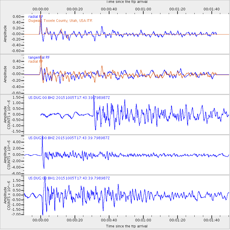
DUG Dugway, Tooele County, Utah, USA - Earthquake Result Viewer
*The percent match for this event was below the threshold and hence no stack was calculated.
| Earthquake location: |
Andreanof Islands, Aleutian Is. |
| Earthquake latitude/longitude: |
51.9/-179.3 |
| Earthquake time(UTC): |
2015/10/05 (278) 17:35:55 GMT |
| Earthquake Depth: |
89 km |
| Earthquake Magnitude: |
5.7 MB |
| Earthquake Catalog/Contributor: |
NEIC PDE/NEIC ALERT |
|
| Network: |
US United States National Seismic Network |
| Station: |
DUG Dugway, Tooele County, Utah, USA |
| Lat/Lon: |
40.19 N/112.81 W |
| Elevation: |
1477 m |
|
| Distance: |
46.1 deg |
| Az: |
77.29 deg |
| Baz: |
307.906 deg |
| Ray Param: |
$rayparam |
*The percent match for this event was below the threshold and hence was not used in the summary stack. |
|
| Radial Match: |
78.42322 % |
| Radial Bump: |
400 |
| Transverse Match: |
72.49144 % |
| Transverse Bump: |
400 |
| SOD ConfigId: |
1156111 |
| Insert Time: |
2015-10-19 18:40:21.368 +0000 |
| GWidth: |
2.5 |
| Max Bumps: |
400 |
| Tol: |
0.001 |
|
Signal To Noise
| Channel | StoN | STA | LTA |
| US:DUG:00:BHZ:20151005T17:43:39.798987Z | 12.625459 | 1.8569228E-6 | 1.4707764E-7 |
| US:DUG:00:BH1:20151005T17:43:39.798987Z | 5.995141 | 9.787358E-7 | 1.6325482E-7 |
| US:DUG:00:BH2:20151005T17:43:39.798987Z | 4.9910913 | 6.4103114E-7 | 1.2843506E-7 |
| Arrivals |
| Ps | |
| PpPs | |
| PsPs/PpSs | |


