You are here: Home > Network List > US - United States National Seismic Network Stations List
> Station MSO Missoula, Montana, USA > Earthquake Result Viewer
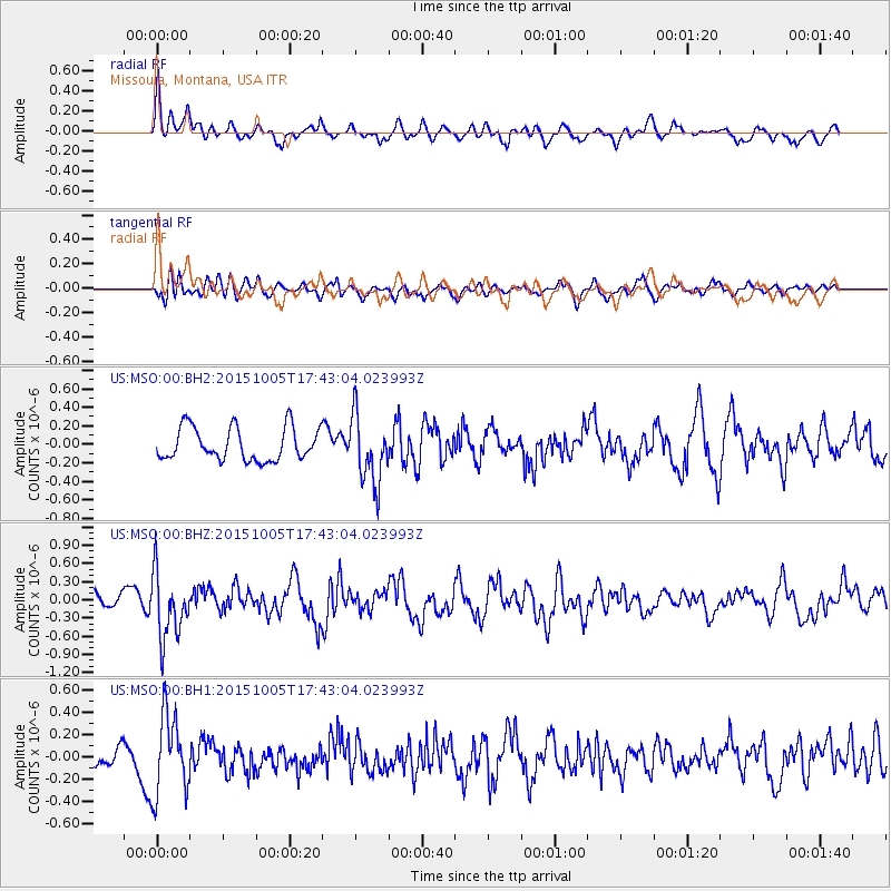
MSO Missoula, Montana, USA - Earthquake Result Viewer
*The percent match for this event was below the threshold and hence no stack was calculated.
| Earthquake location: |
Andreanof Islands, Aleutian Is. |
| Earthquake latitude/longitude: |
51.9/-179.3 |
| Earthquake time(UTC): |
2015/10/05 (278) 17:35:55 GMT |
| Earthquake Depth: |
89 km |
| Earthquake Magnitude: |
5.7 MB |
| Earthquake Catalog/Contributor: |
NEIC PDE/NEIC ALERT |
|
| Network: |
US United States National Seismic Network |
| Station: |
MSO Missoula, Montana, USA |
| Lat/Lon: |
46.83 N/113.94 W |
| Elevation: |
1264 m |
|
| Distance: |
41.6 deg |
| Az: |
70.115 deg |
| Baz: |
301.947 deg |
| Ray Param: |
$rayparam |
*The percent match for this event was below the threshold and hence was not used in the summary stack. |
|
| Radial Match: |
60.06381 % |
| Radial Bump: |
394 |
| Transverse Match: |
52.684196 % |
| Transverse Bump: |
400 |
| SOD ConfigId: |
1156111 |
| Insert Time: |
2015-10-19 18:41:38.549 +0000 |
| GWidth: |
2.5 |
| Max Bumps: |
400 |
| Tol: |
0.001 |
|
Signal To Noise
| Channel | StoN | STA | LTA |
| US:MSO:00:BHZ:20151005T17:43:04.023993Z | 3.8831275 | 5.3191553E-7 | 1.3698123E-7 |
| US:MSO:00:BH1:20151005T17:43:04.023993Z | 3.0778139 | 3.5782764E-7 | 1.1626033E-7 |
| US:MSO:00:BH2:20151005T17:43:04.023993Z | 2.0618021 | 3.657817E-7 | 1.7740872E-7 |
| Arrivals |
| Ps | |
| PpPs | |
| PsPs/PpSs | |


