You are here: Home > Network List > TA - USArray Transportable Network (new EarthScope stations) Stations List
> Station D25K Kavik River, AK, USA > Earthquake Result Viewer
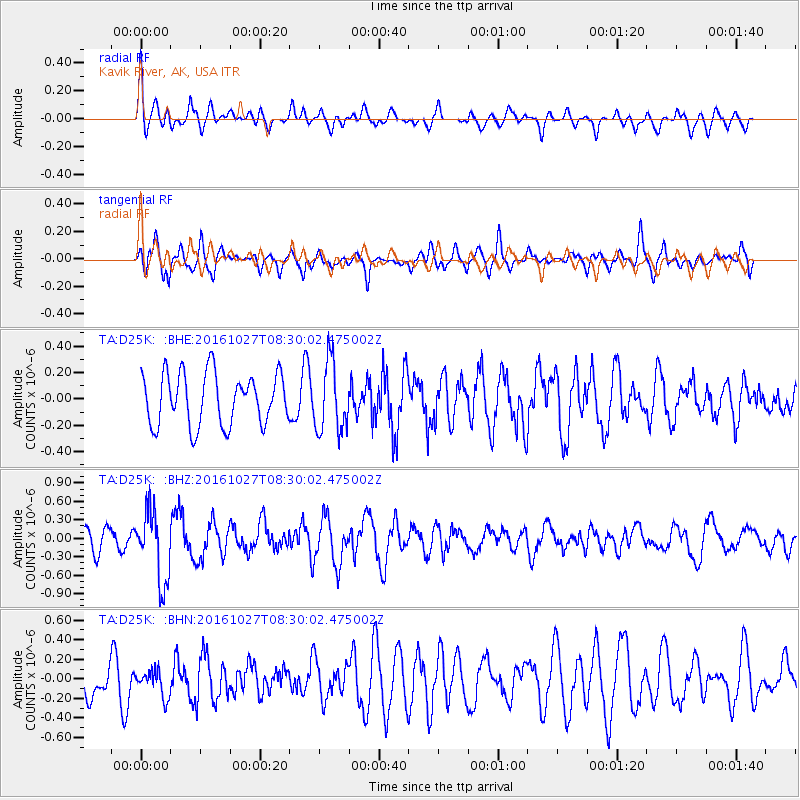
D25K Kavik River, AK, USA - Earthquake Result Viewer
*The percent match for this event was below the threshold and hence no stack was calculated.
| Earthquake location: |
Northern Molucca Sea |
| Earthquake latitude/longitude: |
1.3/125.8 |
| Earthquake time(UTC): |
2016/10/27 (301) 08:17:49 GMT |
| Earthquake Depth: |
56 km |
| Earthquake Magnitude: |
5.9 MB, 5.8 MWB |
| Earthquake Catalog/Contributor: |
NEIC PDE/NEIC COMCAT |
|
| Network: |
TA USArray Transportable Network (new EarthScope stations) |
| Station: |
D25K Kavik River, AK, USA |
| Lat/Lon: |
69.32 N/146.38 W |
| Elevation: |
770 m |
|
| Distance: |
88.0 deg |
| Az: |
20.803 deg |
| Baz: |
268.442 deg |
| Ray Param: |
$rayparam |
*The percent match for this event was below the threshold and hence was not used in the summary stack. |
|
| Radial Match: |
44.788635 % |
| Radial Bump: |
400 |
| Transverse Match: |
65.589935 % |
| Transverse Bump: |
400 |
| SOD ConfigId: |
11737051 |
| Insert Time: |
2019-04-25 22:47:56.511 +0000 |
| GWidth: |
2.5 |
| Max Bumps: |
400 |
| Tol: |
0.001 |
|
Signal To Noise
| Channel | StoN | STA | LTA |
| TA:D25K: :BHZ:20161027T08:30:02.475002Z | 2.9647498 | 5.722614E-7 | 1.9302183E-7 |
| TA:D25K: :BHN:20161027T08:30:02.475002Z | 0.6616673 | 1.3562236E-7 | 2.0497063E-7 |
| TA:D25K: :BHE:20161027T08:30:02.475002Z | 1.3565998 | 2.6479944E-7 | 1.9519348E-7 |
| Arrivals |
| Ps | |
| PpPs | |
| PsPs/PpSs | |


