You are here: Home > Network List > TA - USArray Transportable Network (new EarthScope stations) Stations List
> Station R32K Eaglecrest, AK, USA > Earthquake Result Viewer
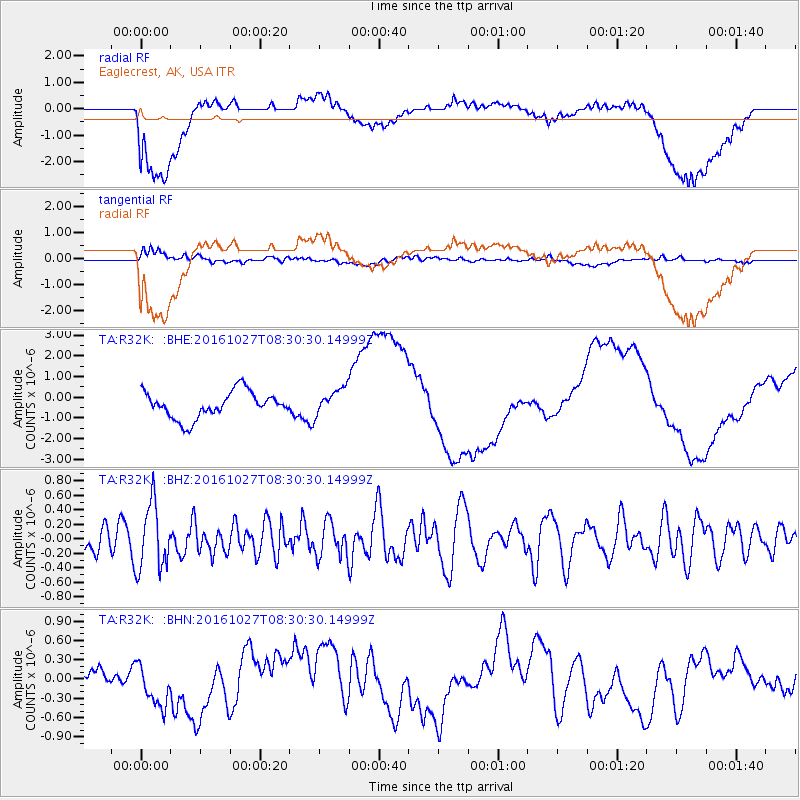
R32K Eaglecrest, AK, USA - Earthquake Result Viewer
*The percent match for this event was below the threshold and hence no stack was calculated.
| Earthquake location: |
Northern Molucca Sea |
| Earthquake latitude/longitude: |
1.3/125.8 |
| Earthquake time(UTC): |
2016/10/27 (301) 08:17:49 GMT |
| Earthquake Depth: |
56 km |
| Earthquake Magnitude: |
5.9 MB, 5.8 MWB |
| Earthquake Catalog/Contributor: |
NEIC PDE/NEIC COMCAT |
|
| Network: |
TA USArray Transportable Network (new EarthScope stations) |
| Station: |
R32K Eaglecrest, AK, USA |
| Lat/Lon: |
58.27 N/134.52 W |
| Elevation: |
386 m |
|
| Distance: |
94.0 deg |
| Az: |
31.475 deg |
| Baz: |
278.939 deg |
| Ray Param: |
$rayparam |
*The percent match for this event was below the threshold and hence was not used in the summary stack. |
|
| Radial Match: |
22.942139 % |
| Radial Bump: |
400 |
| Transverse Match: |
42.809677 % |
| Transverse Bump: |
400 |
| SOD ConfigId: |
11737051 |
| Insert Time: |
2019-04-25 22:48:39.427 +0000 |
| GWidth: |
2.5 |
| Max Bumps: |
400 |
| Tol: |
0.001 |
|
Signal To Noise
| Channel | StoN | STA | LTA |
| TA:R32K: :BHZ:20161027T08:30:30.14999Z | 2.5941 | 4.4879963E-7 | 1.7300783E-7 |
| TA:R32K: :BHN:20161027T08:30:30.14999Z | 1.4858816 | 3.9334634E-7 | 2.6472253E-7 |
| TA:R32K: :BHE:20161027T08:30:30.14999Z | 1.0451641 | 6.6161164E-7 | 6.330217E-7 |
| Arrivals |
| Ps | |
| PpPs | |
| PsPs/PpSs | |


