You are here: Home > Network List > CB - China National Seismic Network Stations List
> Station CD2 Chengdou,Sichuan Province > Earthquake Result Viewer
CD2 Chengdou,Sichuan Province - Earthquake Result Viewer
| Earthquake location: |
Unimak Island Region, Alaska |
| Earthquake latitude/longitude: |
53.6/-163.3 |
| Earthquake time(UTC): |
2016/10/27 (301) 11:53:18 GMT |
| Earthquake Depth: |
17 km |
| Earthquake Magnitude: |
5.8 MWP, 5.8 MI |
| Earthquake Catalog/Contributor: |
NEIC PDE/NEIC COMCAT |
|
| Network: |
CB China National Seismic Network |
| Station: |
CD2 Chengdou,Sichuan Province |
| Lat/Lon: |
30.91 N/103.76 E |
| Elevation: |
653 m |
|
| Distance: |
67.4 deg |
| Az: |
291.62 deg |
| Baz: |
40.113 deg |
| Ray Param: |
0.056957915 |
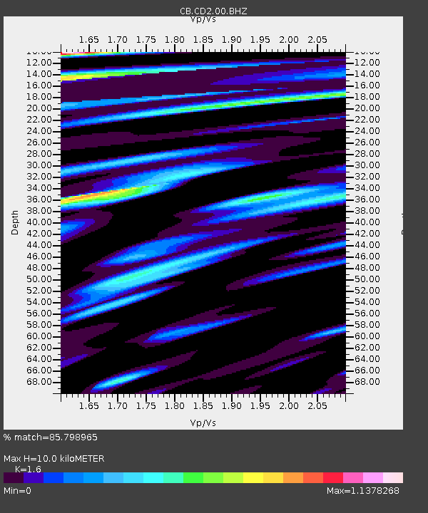
| Estimated Moho Depth: |
10.0 km |
| Estimated Crust Vp/Vs: |
1.60 |
| Assumed Crust Vp: |
6.159 km/s |
| Estimated Crust Vs: |
3.849 km/s |
| Estimated Crust Poisson's Ratio: |
0.18 |
|
| Radial Match: |
85.798965 % |
| Radial Bump: |
400 |
| Transverse Match: |
83.390175 % |
| Transverse Bump: |
400 |
| SOD ConfigId: |
11737051 |
| Insert Time: |
2019-04-25 22:50:27.364 +0000 |
| GWidth: |
2.5 |
| Max Bumps: |
400 |
| Tol: |
0.001 |
|

Signal To Noise
| Channel | StoN | STA | LTA |
| CB:CD2:00:BHZ:20161027T12:03:41.33998Z | 6.5775976 | 1.743425E-6 | 2.6505498E-7 |
| CB:CD2:00:BHN:20161027T12:03:41.33998Z | 2.944354 | 4.0523202E-7 | 1.376302E-7 |
| CB:CD2:00:BHE:20161027T12:03:41.33998Z | 2.9879005 | 3.0272807E-7 | 1.01317994E-7 |
| Arrivals |
| Ps | 1.0 SECOND |
| PpPs | 4.1 SECOND |
| PsPs/PpSs | 5.1 SECOND |


