You are here: Home > Network List > CI - Caltech Regional Seismic Network Stations List
> Station MPM Manuel Prospect Mine, California, USA > Earthquake Result Viewer
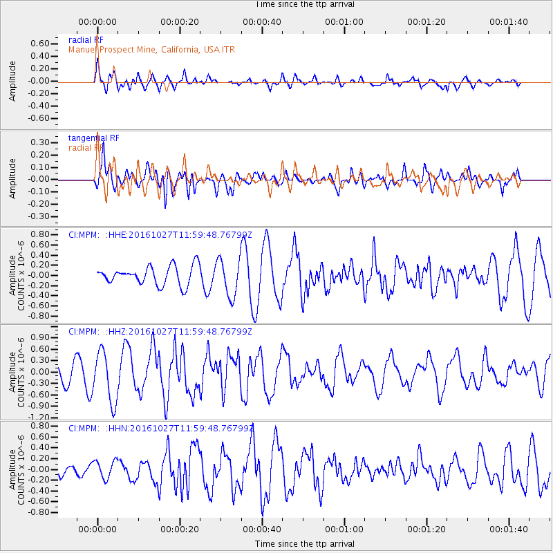
MPM Manuel Prospect Mine, California, USA - Earthquake Result Viewer
*The percent match for this event was below the threshold and hence no stack was calculated.
| Earthquake location: |
Unimak Island Region, Alaska |
| Earthquake latitude/longitude: |
53.6/-163.3 |
| Earthquake time(UTC): |
2016/10/27 (301) 11:53:18 GMT |
| Earthquake Depth: |
17 km |
| Earthquake Magnitude: |
5.8 MWP, 5.8 MI |
| Earthquake Catalog/Contributor: |
NEIC PDE/NEIC COMCAT |
|
| Network: |
CI Caltech Regional Seismic Network |
| Station: |
MPM Manuel Prospect Mine, California, USA |
| Lat/Lon: |
36.06 N/117.49 W |
| Elevation: |
185 m |
|
| Distance: |
36.2 deg |
| Az: |
100.227 deg |
| Baz: |
313.66 deg |
| Ray Param: |
$rayparam |
*The percent match for this event was below the threshold and hence was not used in the summary stack. |
|
| Radial Match: |
69.12842 % |
| Radial Bump: |
400 |
| Transverse Match: |
73.00026 % |
| Transverse Bump: |
400 |
| SOD ConfigId: |
11737051 |
| Insert Time: |
2019-04-25 22:50:57.602 +0000 |
| GWidth: |
2.5 |
| Max Bumps: |
400 |
| Tol: |
0.001 |
|
Signal To Noise
| Channel | StoN | STA | LTA |
| CI:MPM: :HHZ:20161027T11:59:48.76799Z | 4.18592 | 6.7654935E-7 | 1.6162501E-7 |
| CI:MPM: :HHN:20161027T11:59:48.76799Z | 1.0620748 | 1.6691264E-7 | 1.5715715E-7 |
| CI:MPM: :HHE:20161027T11:59:48.76799Z | 2.0647297 | 3.7931525E-7 | 1.8371183E-7 |
| Arrivals |
| Ps | |
| PpPs | |
| PsPs/PpSs | |


