You are here: Home > Network List > TA - USArray Transportable Network (new EarthScope stations) Stations List
> Station 833A Chaparral WMA, Artesia Wells, TX, USA > Earthquake Result Viewer
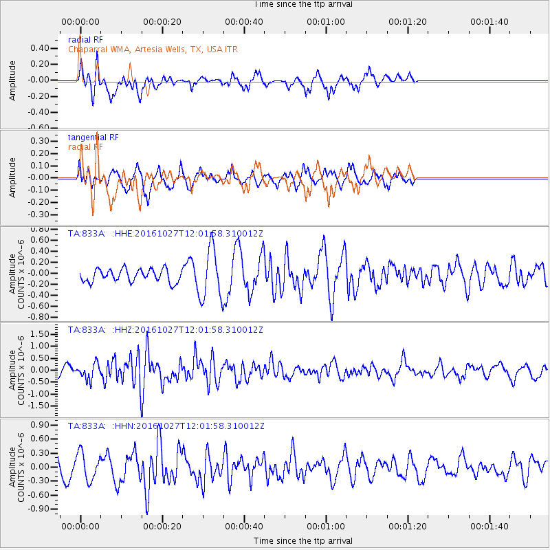
833A Chaparral WMA, Artesia Wells, TX, USA - Earthquake Result Viewer
*The percent match for this event was below the threshold and hence no stack was calculated.
| Earthquake location: |
Unimak Island Region, Alaska |
| Earthquake latitude/longitude: |
53.6/-163.3 |
| Earthquake time(UTC): |
2016/10/27 (301) 11:53:18 GMT |
| Earthquake Depth: |
17 km |
| Earthquake Magnitude: |
5.8 MWP, 5.8 MI |
| Earthquake Catalog/Contributor: |
NEIC PDE/NEIC COMCAT |
|
| Network: |
TA USArray Transportable Network (new EarthScope stations) |
| Station: |
833A Chaparral WMA, Artesia Wells, TX, USA |
| Lat/Lon: |
28.32 N/99.39 W |
| Elevation: |
171 m |
|
| Distance: |
52.4 deg |
| Az: |
92.212 deg |
| Baz: |
317.533 deg |
| Ray Param: |
$rayparam |
*The percent match for this event was below the threshold and hence was not used in the summary stack. |
|
| Radial Match: |
70.10945 % |
| Radial Bump: |
353 |
| Transverse Match: |
65.45521 % |
| Transverse Bump: |
299 |
| SOD ConfigId: |
11737051 |
| Insert Time: |
2019-04-25 22:57:03.790 +0000 |
| GWidth: |
2.5 |
| Max Bumps: |
400 |
| Tol: |
0.001 |
|
Signal To Noise
| Channel | StoN | STA | LTA |
| TA:833A: :HHZ:20161027T12:01:58.310012Z | 2.2440038 | 3.3430118E-7 | 1.4897532E-7 |
| TA:833A: :HHN:20161027T12:01:58.310012Z | 2.0470655 | 2.9891933E-7 | 1.4602334E-7 |
| TA:833A: :HHE:20161027T12:01:58.310012Z | 4.147597 | 4.7191247E-7 | 1.13779734E-7 |
| Arrivals |
| Ps | |
| PpPs | |
| PsPs/PpSs | |


