You are here: Home > Network List > TJ - Tajikistan National Seismic Network Stations List
> Station GARM Garm, Tajikistan > Earthquake Result Viewer
GARM Garm, Tajikistan - Earthquake Result Viewer
| Earthquake location: |
Unimak Island Region, Alaska |
| Earthquake latitude/longitude: |
53.6/-163.3 |
| Earthquake time(UTC): |
2016/10/27 (301) 11:53:18 GMT |
| Earthquake Depth: |
17 km |
| Earthquake Magnitude: |
5.8 MWP, 5.8 MI |
| Earthquake Catalog/Contributor: |
NEIC PDE/NEIC COMCAT |
|
| Network: |
TJ Tajikistan National Seismic Network |
| Station: |
GARM Garm, Tajikistan |
| Lat/Lon: |
39.00 N/70.32 E |
| Elevation: |
1305 m |
|
| Distance: |
76.8 deg |
| Az: |
319.903 deg |
| Baz: |
29.496 deg |
| Ray Param: |
0.05072194 |
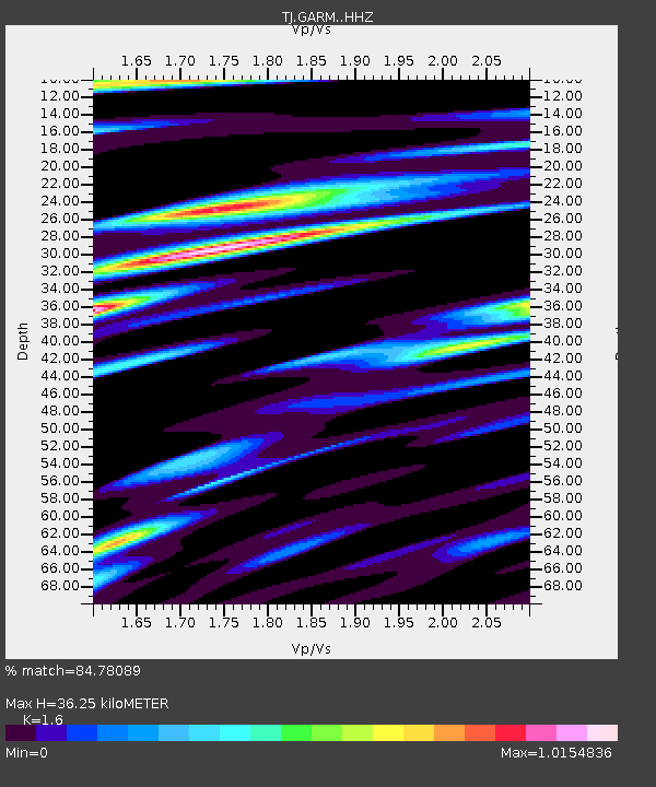
| Estimated Moho Depth: |
36.25 km |
| Estimated Crust Vp/Vs: |
1.60 |
| Assumed Crust Vp: |
6.306 km/s |
| Estimated Crust Vs: |
3.941 km/s |
| Estimated Crust Poisson's Ratio: |
0.18 |
|
| Radial Match: |
84.78089 % |
| Radial Bump: |
400 |
| Transverse Match: |
75.94632 % |
| Transverse Bump: |
400 |
| SOD ConfigId: |
11737051 |
| Insert Time: |
2019-04-25 22:57:27.539 +0000 |
| GWidth: |
2.5 |
| Max Bumps: |
400 |
| Tol: |
0.001 |
|

Signal To Noise
| Channel | StoN | STA | LTA |
| TJ:GARM: :HHZ:20161027T12:04:37.510024Z | 22.288342 | 1.8588036E-6 | 8.339802E-8 |
| TJ:GARM: :HHN:20161027T12:04:37.510024Z | 2.8669775 | 3.3819927E-7 | 1.179637E-7 |
| TJ:GARM: :HHE:20161027T12:04:37.510024Z | 2.6745358 | 3.5086796E-7 | 1.3118837E-7 |
| Arrivals |
| Ps | 3.6 SECOND |
| PpPs | 14 SECOND |
| PsPs/PpSs | 18 SECOND |


