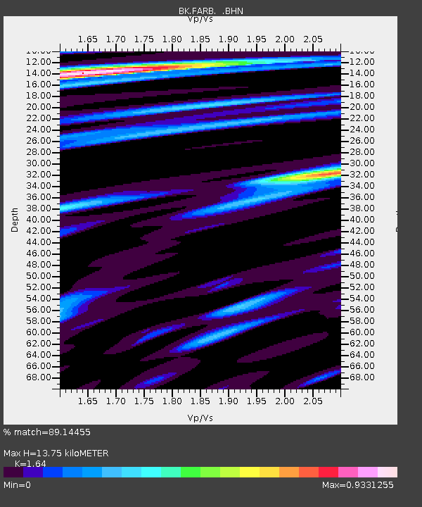
FARB Farallon Islands, CA - Earthquake Result Viewer
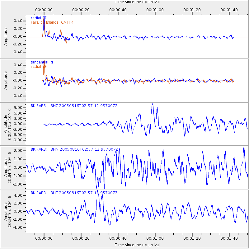
Earthquake location: Near East Coast Of Honshu, Japan
Earthquake latitude/longitude: 38.3/142.0
Earthquake time(UTC): 2005/08/16 (228) 02:46:28 GMT
Earthquake Depth: 36 km
Earthquake Magnitude: 6.5 MB, 6.8 MS, 7.2 MW, 7.1 MW
Earthquake Catalog/Contributor: WHDF/NEIC
Network: BK Berkeley Digital Seismograph Network
Station: FARB Farallon Islands, CA
Lat/Lon: 37.70 N/123.00 W
Elevation: -18.5 m
Distance: 71.2 deg
Az: 56.576 deg
Baz: 304.094 deg
Ray Param: 0.054405395
Estimated Moho Depth: 13.75 km
Estimated Crust Vp/Vs: 1.64
Assumed Crust Vp: 6.183 km/s
Estimated Crust Vs: 3.77 km/s
Estimated Crust Poisson's Ratio: 0.20
Radial Match: 89.14455 %
Radial Bump: 346
Transverse Match: 80.81874 %
Transverse Bump: 400
SOD ConfigId: 124340
Insert Time: 2010-03-05 19:15:38.082 +0000
GWidth: 2.5
Max Bumps: 400
Tol: 0.001

Signal To Noise

ChannelStoNSTALTA
BK:FARB: :BHN:20050816T02:57:12.957007Z0.62880382.6753892E-74.254728E-7
BK:FARB: :BHE:20050816T02:57:12.957007Z1.68096965.722337E-73.4041884E-7
BK:FARB: :BHZ:20050816T02:57:12.957007Z1.90485386.7767036E-73.5575977E-7
Arrivals
Ps1.5 SECOND
PpPs5.7 SECOND
PsPs/PpSs7.1 SECOND