You are here: Home > Network List > WY - Yellowstone Wyoming Seismic Network Stations List
> Station YHH Holmes Hill, YNP, WY, USA > Earthquake Result Viewer
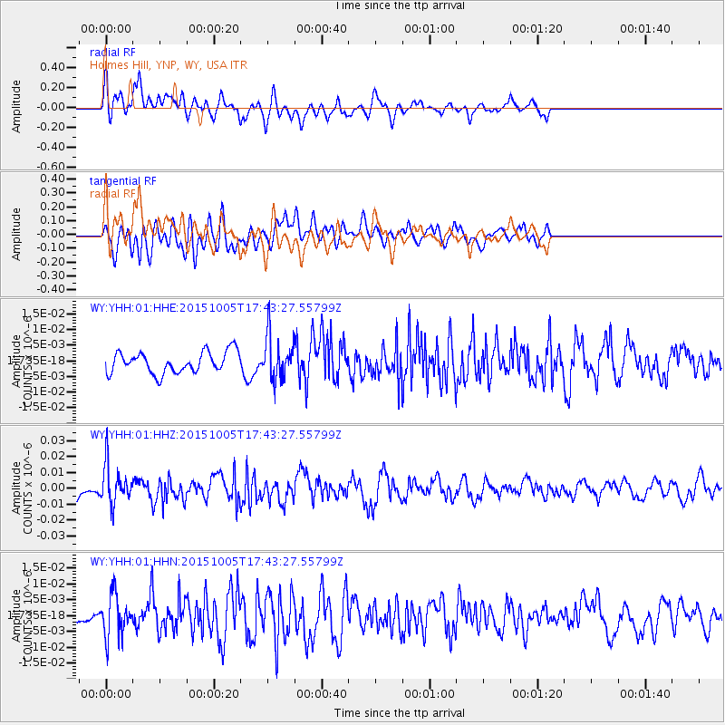
YHH Holmes Hill, YNP, WY, USA - Earthquake Result Viewer
*The percent match for this event was below the threshold and hence no stack was calculated.
| Earthquake location: |
Andreanof Islands, Aleutian Is. |
| Earthquake latitude/longitude: |
51.9/-179.3 |
| Earthquake time(UTC): |
2015/10/05 (278) 17:35:55 GMT |
| Earthquake Depth: |
89 km |
| Earthquake Magnitude: |
5.7 MB |
| Earthquake Catalog/Contributor: |
NEIC PDE/NEIC ALERT |
|
| Network: |
WY Yellowstone Wyoming Seismic Network |
| Station: |
YHH Holmes Hill, YNP, WY, USA |
| Lat/Lon: |
44.79 N/110.85 W |
| Elevation: |
2717 m |
|
| Distance: |
44.5 deg |
| Az: |
70.874 deg |
| Baz: |
304.71 deg |
| Ray Param: |
$rayparam |
*The percent match for this event was below the threshold and hence was not used in the summary stack. |
|
| Radial Match: |
67.079605 % |
| Radial Bump: |
400 |
| Transverse Match: |
46.780437 % |
| Transverse Bump: |
400 |
| SOD ConfigId: |
1156111 |
| Insert Time: |
2015-10-19 18:44:49.463 +0000 |
| GWidth: |
2.5 |
| Max Bumps: |
400 |
| Tol: |
0.001 |
|
Signal To Noise
| Channel | StoN | STA | LTA |
| WY:YHH:01:HHZ:20151005T17:43:27.55799Z | 2.1014347 | 1.26499E-8 | 6.0196492E-9 |
| WY:YHH:01:HHN:20151005T17:43:27.55799Z | 1.4981432 | 6.720196E-9 | 4.4856834E-9 |
| WY:YHH:01:HHE:20151005T17:43:27.55799Z | 2.0436065 | 6.950129E-9 | 3.4009136E-9 |
| Arrivals |
| Ps | |
| PpPs | |
| PsPs/PpSs | |


