You are here: Home > Network List > BK - Berkeley Digital Seismograph Network Stations List
> Station FARB Farallon Islands, CA > Earthquake Result Viewer
FARB Farallon Islands, CA - Earthquake Result Viewer
| Earthquake location: |
Fiji Islands Region |
| Earthquake latitude/longitude: |
-15.3/-178.6 |
| Earthquake time(UTC): |
2005/12/13 (347) 03:16:06 GMT |
| Earthquake Depth: |
10 km |
| Earthquake Magnitude: |
6.1 MB, 6.8 MS, 6.7 MW, 6.7 MW |
| Earthquake Catalog/Contributor: |
WHDF/NEIC |
|
| Network: |
BK Berkeley Digital Seismograph Network |
| Station: |
FARB Farallon Islands, CA |
| Lat/Lon: |
37.70 N/123.00 W |
| Elevation: |
-18.5 m |
|
| Distance: |
74.1 deg |
| Az: |
42.86 deg |
| Baz: |
235.858 deg |
| Ray Param: |
0.05254427 |
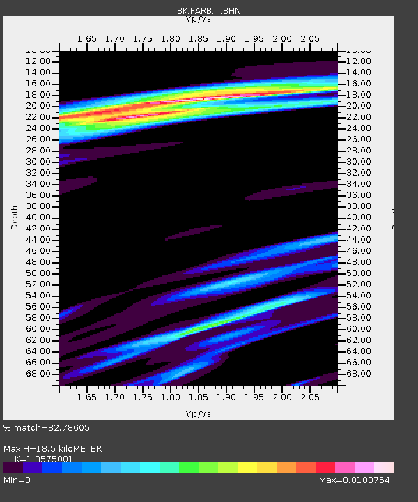
| Estimated Moho Depth: |
18.5 km |
| Estimated Crust Vp/Vs: |
1.86 |
| Assumed Crust Vp: |
6.183 km/s |
| Estimated Crust Vs: |
3.328 km/s |
| Estimated Crust Poisson's Ratio: |
0.30 |
|
| Radial Match: |
82.78605 % |
| Radial Bump: |
400 |
| Transverse Match: |
77.492874 % |
| Transverse Bump: |
400 |
| SOD ConfigId: |
2422 |
| Insert Time: |
2010-03-05 19:15:49.971 +0000 |
| GWidth: |
2.5 |
| Max Bumps: |
400 |
| Tol: |
0.001 |
|
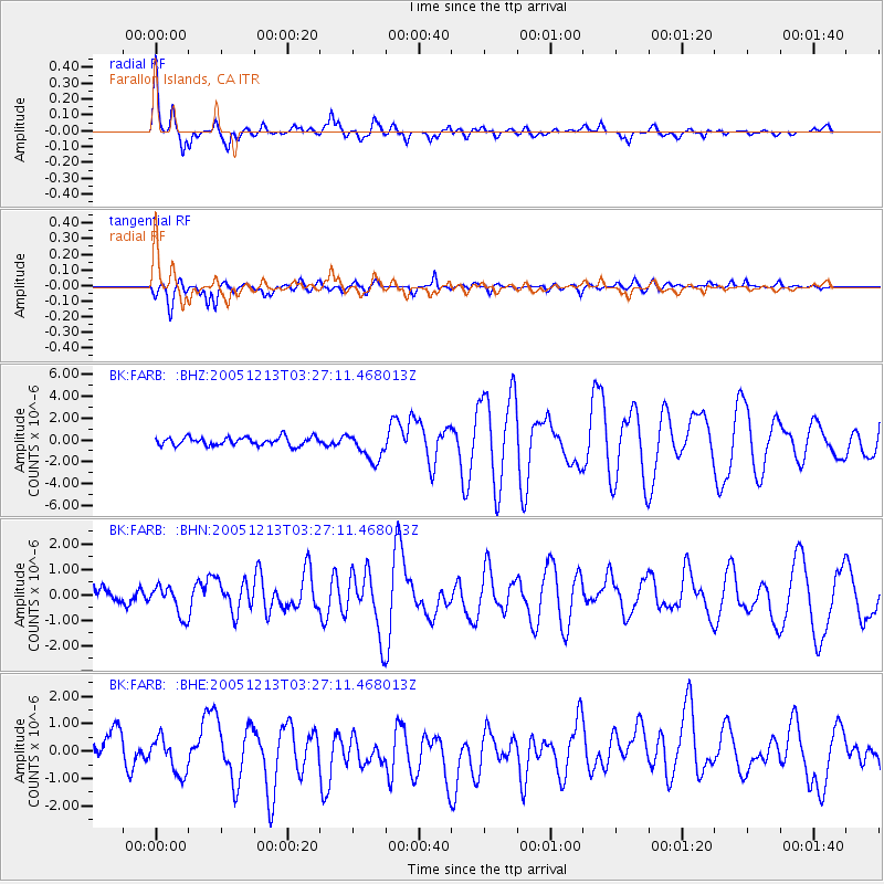
Signal To Noise
| Channel | StoN | STA | LTA |
| BK:FARB: :BHN:20051213T03:27:11.468013Z | 1.57924 | 5.692832E-7 | 3.6047922E-7 |
| BK:FARB: :BHE:20051213T03:27:11.468013Z | 1.5806621 | 6.9212416E-7 | 4.3786977E-7 |
| BK:FARB: :BHZ:20051213T03:27:11.468013Z | 3.4522035 | 1.3119857E-6 | 3.8004296E-7 |
| Arrivals |
| Ps | 2.6 SECOND |
| PpPs | 8.3 SECOND |
| PsPs/PpSs | 11 SECOND |


