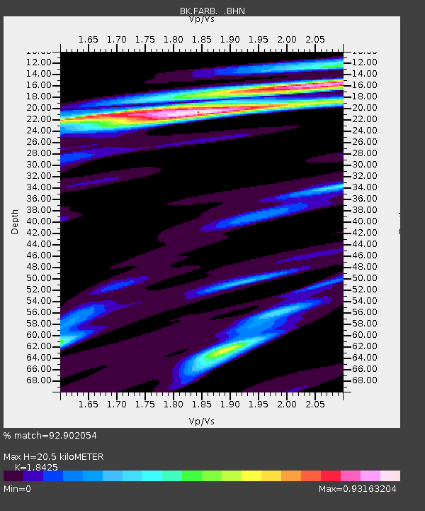
FARB Farallon Islands, CA - Earthquake Result Viewer
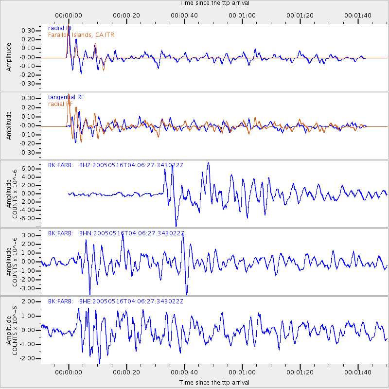
Earthquake location: South Of Kermadec Islands
Earthquake latitude/longitude: -32.6/-179.4
Earthquake time(UTC): 2005/05/16 (136) 03:54:14 GMT
Earthquake Depth: 34 km
Earthquake Magnitude: 6.2 MB, 6.4 MS, 6.6 MW, 6.6 MW
Earthquake Catalog/Contributor: WHDF/NEIC
Network: BK Berkeley Digital Seismograph Network
Station: FARB Farallon Islands, CA
Lat/Lon: 37.70 N/123.00 W
Elevation: -18.5 m
Distance: 87.4 deg
Az: 41.375 deg
Baz: 224.705 deg
Ray Param: 0.043280117
Estimated Moho Depth: 20.5 km
Estimated Crust Vp/Vs: 1.84
Assumed Crust Vp: 6.183 km/s
Estimated Crust Vs: 3.356 km/s
Estimated Crust Poisson's Ratio: 0.29
Radial Match: 92.902054 %
Radial Bump: 400
Transverse Match: 88.71365 %
Transverse Bump: 379
SOD ConfigId: 124340
Insert Time: 2010-03-05 19:16:01.836 +0000
GWidth: 2.5
Max Bumps: 400
Tol: 0.001

Signal To Noise

ChannelStoNSTALTA
BK:FARB: :BHN:20050516T04:06:27.343022Z2.28013165.131789E-72.2506548E-7
BK:FARB: :BHE:20050516T04:06:27.343022Z2.96380456.512341E-72.197291E-7
BK:FARB: :BHZ:20050516T04:06:27.343022Z7.713231.942824E-62.5188203E-7
Arrivals
Ps2.8 SECOND
PpPs9.2 SECOND
PsPs/PpSs12 SECOND